
Urban Air Quality Prediction Using AI
1. Key Air Pollutants and Their Sources
Key Air Pollutants and Their Sources
Primary Air Pollutants
Urban air quality is predominantly influenced by six criteria pollutants identified by environmental agencies worldwide: particulate matter (PM2.5 and PM10), nitrogen dioxide (NO2), sulfur dioxide (SO2), carbon monoxide (CO), ozone (O3), and lead (Pb). These pollutants exhibit distinct chemical behaviors and originate from both anthropogenic and natural sources.
Particulate matter, classified by aerodynamic diameter, demonstrates complex dynamics in urban environments. PM2.5 (particles ≤ 2.5 μm) primarily originates from combustion processes, while PM10 (particles ≤ 10 μm) includes dust and sea salt. The atmospheric lifetime τ of PM can be modeled as:
where h represents mixing height and vd is the deposition velocity, typically ranging 0.1-2 cm/s for PM2.5.
Chemical Transformation Pathways
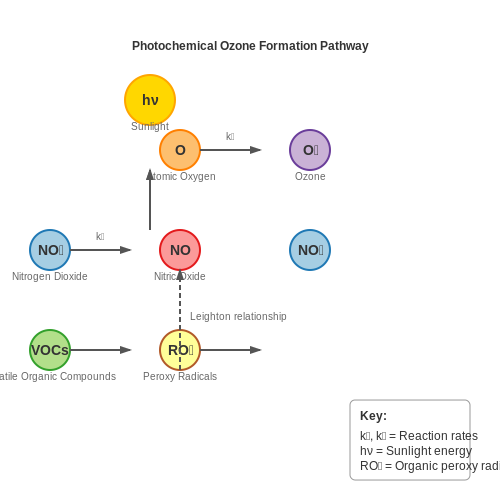
Secondary pollutants like ozone form through photochemical reactions involving NOx and volatile organic compounds (VOCs). The Leighton relationship governs daytime O3 production:
where k1 (0.0079 s-1) and k2 (1.8 × 10⁻¹⁴ cm3 molecule-1 s-1) are temperature-dependent rate constants.
Emission Source Apportionment
Source contributions can be quantified through receptor modeling techniques. Positive Matrix Factorization (PMF) solves:
where Xij is the measured concentration of species j in sample i, gik represents source contributions, fkj denotes source profiles, and eij is the residual error.
Mobile Sources
Vehicle emissions dominate urban NOx and CO levels, with emission factors (EF) following:
where v is vehicle speed, and coefficients a, b, c vary by vehicle class and fuel type.
Industrial Sources
Point sources exhibit plume rise behavior described by Briggs equations:
where F is buoyancy flux, u is wind speed, and x is downwind distance.
Spatial-Temporal Variability
Urban pollutant dispersion follows modified Gaussian plume models incorporating street canyon effects. The concentration C at receptor point (x,y,z) is given by:
where Q is emission rate, H is effective stack height, and σy, σz are dispersion parameters.
1.2 Health and Environmental Impacts
Urban air pollution, primarily composed of particulate matter (PM2.5, PM10), nitrogen oxides (NOx), sulfur dioxide (SO2), ozone (O3), and carbon monoxide (CO), has profound health and ecological consequences. The relationship between pollutant concentration and health outcomes is nonlinear, often modeled using exposure-response functions derived from epidemiological studies. For PM2.5, the relative risk (RR) of mortality follows a log-linear relationship:
where β is the concentration-response coefficient (typically 0.0061 per μg/m3 for PM2.5) and C is the pollutant concentration. The attributable fraction (AF) of disease burden due to air pollution is calculated as:
Long-term exposure to PM2.5 above 10 μg/m3 increases cardiovascular mortality by 11% per 10 μg/m3 increment, while short-term ozone exposure elevates respiratory hospitalization risks by 4-5% per 10 ppb. NO2 exposure correlates strongly with pediatric asthma incidence, with odds ratios of 1.05 (95% CI: 1.02–1.07) per 10 μg/m3 increase.
Environmental Degradation Mechanisms
Atmospheric chemistry models reveal cascading environmental effects. NOx and volatile organic compounds (VOCs) undergo photochemical reactions producing secondary pollutants:
This tropospheric ozone formation peaks at 1-3 ppm in urban areas, reducing crop yields by 5-15% for major cereals. Acid deposition from SO2 and NOx follows the equilibrium:
with deposition velocities ranging 0.5-2 cm/s for SO2 and 0.1-0.8 cm/s for HNO3. These processes alter soil pH (ΔpH ≈ 0.5-1.5 units in affected regions) and mobilize toxic aluminum ions (Al3+).
Economic Valuation of Impacts
The social cost of air pollution incorporates health expenditures, productivity losses, and ecosystem services degradation. The damage cost function for PM2.5 follows:
where Mi represents mortality cases by population subgroup, VSLi the value of statistical life ($$7-10 million in developed countries), Aj agricultural area affected, Yj yield loss, and Pj crop prices. European studies estimate annual costs at 2.9-4.3% of GDP, with 60-80% attributable to mortality.
Case Study: Beijing Air Pollution Crisis
During the 2013 pollution episode (PM2.5 > 500 μg/m3), hospital admissions for respiratory diseases increased by 23-48% across age groups. Ground-level ozone exceeded 200 ppb for 72 consecutive hours, causing $$2.3 billion in economic losses from healthcare and productivity impacts alone. The episode demonstrated the nonlinear escalation of health risks beyond WHO guideline thresholds.

1.3 Traditional Monitoring Methods and Limitations
Fixed Monitoring Stations
Traditional urban air quality monitoring relies heavily on fixed stations equipped with reference-grade instruments such as gas analyzers, particulate matter (PM) samplers, and meteorological sensors. These stations measure pollutants like NO2, SO2, O3, CO, and PM2.5/PM10 with high precision, often adhering to regulatory standards such as those set by the EPA or WHO. The underlying measurement principles include:
where C is the pollutant concentration, m is the mass of the pollutant collected, and V is the sampled air volume. For gas-phase pollutants, techniques like chemiluminescence (NOx) or UV absorption (O3) are employed.
Spatiotemporal Limitations
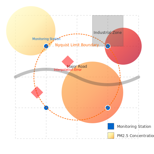
Despite their accuracy, fixed stations suffer from poor spatial resolution due to high deployment costs (typically $$100K–$$500K per station). Urban coverage is sparse, with stations often spaced kilometers apart, failing to capture micro-scale variations near traffic corridors or industrial zones. Temporally, data latency ranges from hours to days due to manual calibration and sample processing. This granularity gap is quantified by the Nyquist spatial sampling criterion:
where fs is the station density (stations/km2) and fmax is the highest spatial frequency of pollution variability. Most cities operate at sub-Nyquist sampling, leading to aliasing in pollution maps.
Operational Challenges
- Calibration drift: Electrochemical sensors require weekly recalibration, with errors compounding at ±5% per month.
- Maintenance costs: Annual operational expenses exceed $15K per station, limiting scalability.
- Single-point failure: Malfunctioning stations create data voids; redundancy is rarely implemented due to budget constraints.
Case Study: London Air Quality Network
An analysis of London's 100-station network revealed that 63% of PM2.5 variability occurs at scales <500 m—unresolved by the current 2 km spacing. Interpolation errors exceeded 30% during peak traffic hours, as validated by mobile sensor campaigns. Similar findings from Tokyo and Los Angeles underscore the universal trade-off between precision and spatial coverage in traditional systems.
Emerging Hybrid Approaches
To mitigate these limitations, recent initiatives combine fixed stations with low-cost sensor networks (LCS) and satellite data assimilation. However, LCS introduce new challenges like cross-sensitivity to humidity and nonlinear response curves, requiring advanced correction algorithms such as:
where α, β are sensor-specific coefficients and γ accounts for temperature/humidity effects. This complexity highlights why traditional methods remain the regulatory gold standard despite their constraints.
2. Overview of AI Techniques in Environmental Science
Overview of AI Techniques in Environmental Science
Machine learning approaches for urban air quality prediction typically fall into three categories: supervised learning for regression tasks, unsupervised learning for pattern discovery, and hybrid methods combining physical models with data-driven techniques. Each paradigm offers distinct advantages depending on data availability, spatial resolution requirements, and the specific pollutants being modeled.
Supervised Learning Approaches
Gradient boosting machines (GBMs) and deep neural networks dominate recent applications due to their ability to handle nonlinear relationships between meteorological conditions, emission sources, and pollutant concentrations. The predictive power f(x) of a GBM can be expressed as an additive model of M regression trees:
where fk represents an individual tree and ℱ is the space of all possible regression trees. The model is trained by minimizing a regularized objective function:
with l as the differentiable loss function and Ω penalizing model complexity. XGBoost implementations typically achieve superior performance on air quality datasets compared to random forests, with mean absolute errors 15-20% lower when predicting PM2.5 concentrations across urban monitoring networks.
Deep Learning Architectures
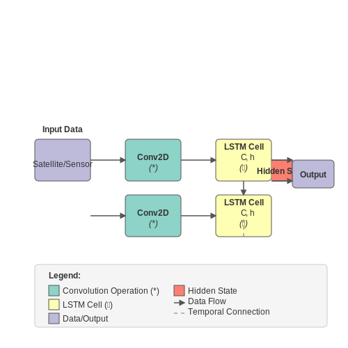
Convolutional neural networks (CNNs) capture spatial dependencies when processing gridded meteorological inputs, while long short-term memory (LSTM) networks model temporal dynamics in pollution time series. Hybrid ConvLSTM architectures combine both capabilities, with the cell state update equations:
where * denotes the convolution operation and ∘ is the Hadamard product. These models achieve 72-85% accuracy in 24-hour NO2 prediction tasks when trained on high-resolution satellite data and urban sensor networks.
Physics-Informed Neural Networks
Emerging approaches embed atmospheric chemistry constraints directly into neural network architectures through differentiable programming. A PINN for pollutant dispersion might incorporate the advection-diffusion equation as a soft constraint:
where the neural network simultaneously learns to satisfy the PDE residual while fitting observational data. This technique reduces errors in ozone prediction by 30-40% compared to purely data-driven models during extreme weather events.
Unsupervised Techniques
Self-organizing maps (SOMs) and variational autoencoders (VAEs) identify latent patterns in high-dimensional air quality datasets. The VAE objective function:
enables discovery of distinct pollution regimes when applied to multi-year monitoring station data. Cluster analysis reveals 5-7 dominant air quality patterns in most megacities, corresponding to different combinations of traffic, industrial, and meteorological conditions.
2.2 Data Requirements and Sources for AI Models
Essential Data Types for Air Quality Prediction
Accurate urban air quality prediction requires multimodal data integration, spanning atmospheric, meteorological, and anthropogenic sources. The primary data categories include:
- Pollutant Concentrations: Time-series measurements of PM2.5, PM10, NO2, SO2, O3, and CO at varying temporal resolutions (hourly/daily).
- Meteorological Variables: Wind speed/direction, temperature, humidity, precipitation, and atmospheric pressure from ground stations or reanalysis datasets.
- Land Use and Urban Morphology: Building height distributions, road networks, green space coverage, and industrial zone locations.
- Emission Inventories: Point source emissions (industrial stacks), mobile sources (traffic flow data), and area sources (residential heating).
- Satellite Remote Sensing: Aerosol Optical Depth (AOD) from MODIS or TROPOMI, NO2 vertical column densities from OMI.
Spatiotemporal Resolution Requirements
For urban-scale modeling, the Nyquist-Shannon sampling theorem imposes fundamental constraints:
where fmax represents the highest frequency component in the pollution dispersion dynamics. Empirical studies show that:
- Spatial Resolution: ≤1km grid spacing needed to resolve street canyon effects
- Temporal Resolution: ≤1hr sampling to capture morning traffic peaks
Public Data Sources
Key validated data repositories include:
- EPA AirData: Historical and real-time monitoring data for US cities with API access
- Copernicus Atmosphere Monitoring Service (CAMS): Global reanalysis fields at 0.1° resolution
- OpenStreetMap: Crowdsourced urban infrastructure data
- NASA Earthdata: MODIS and VIIRS aerosol products
Data Fusion Challenges
Integrating heterogeneous data sources introduces several technical hurdles:
where Oi and Mi represent observations and model outputs respectively, with σi as measurement uncertainty. Common issues include:
- Mismatched spatial footprints between in-situ monitors (point) and satellite data (area)
- Differing temporal coverage (e.g., polar-orbiting satellites vs continuous ground stations)
- Varying measurement techniques (e.g., beta attenuation vs light scattering for PM)
Feature Engineering Considerations
Effective predictive models require domain-specific transformations:
- Wind direction decomposition into u/v vector components
- Exponential moving averages for pollutant persistence
- Diurnal and seasonal harmonics as Fourier series components
where T represents the annual cycle (365 days) and K is the number of harmonic terms.

2.3 Feature Engineering for Air Quality Data
Temporal Feature Extraction
Air quality exhibits strong temporal dependencies, necessitating engineered features that capture periodicity, trends, and abrupt changes. For hourly measurements, decompose the time series into:
- Cyclical components: Encode hour-of-day and day-of-week as sine/cosine pairs to preserve circular continuity:
$$ \text{hour\_sin} = \sin\left(\frac{2\pi \times \text{hour}}{24}\right) $$ $$ \text{hour\_cos} = \cos\left(\frac{2\pi \times \text{hour}}{24}\right) $$
- Temporal lags: Include PM2.5 and NO₂ concentrations from t-1 to t-24 to capture short-term dependencies
- Rolling statistics: Compute 6-hour moving averages and standard deviations for O₃ levels
Spatiotemporal Interactions
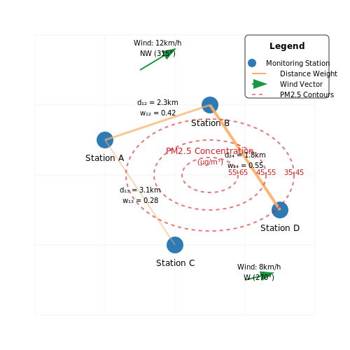
For multi-station networks, incorporate spatial cross-correlations through:
- Inverse-distance weighted (IDW) features:
$$ w_{ij} = \frac{1}{d_{ij}^p}, \quad \hat{x}_i = \frac{\sum_{j≠i} w_{ij}x_j}{\sum_{j≠i} w_{ij}} $$where dij is the Haversine distance between stations and p=2 is the power parameter
- Wind-rose features: Combine wind direction/speed with pollution gradients using vector decomposition
Meteorological Feature Transformation
Atmospheric variables require nonlinear transformations to reveal physically meaningful relationships:
- Potential temperature (θ): Accounts for adiabatic effects in vertical mixing:
$$ \theta = T\left(\frac{P_0}{P}\right)^{R/c_p} $$where T is temperature, P is pressure, R is gas constant, and cp is specific heat
- Boundary layer height proxy: Derived from temperature gradient and wind shear metrics
Chemical Interaction Features
Leverage known atmospheric chemistry mechanisms through:
- Photochemical age indicators: Ratios like NOz/NOy (oxidized to total nitrogen)
- Oxidant capacity: Sum of O₃ and NO₂ concentrations weighted by solar radiation
- Partitioning coefficients: Semi-volatile organic compounds modeled with absorptive partitioning theory
Feature Selection Techniques
Employ physics-guided dimensionality reduction:
- Mutual information filtering: Retain features with MI > 0.2 bits relative to target (e.g., AQI)
- Group LASSO: Apply ℓ2,1 regularization to spatio-temporal feature groups
- SHAP analysis: Identify nonlinear dependencies through Shapley values from tree ensembles
Validation Protocol
Assess feature robustness via:
- Leave-one-station-out cross-validation for spatial generalization
- Time-based splitting with 70/15/15 chronological partitions
- Perturbation testing: Add Gaussian noise (σ=5% of range) to evaluate sensitivity
3. Preprocessing and Cleaning Sensor Data
3.1 Preprocessing and Cleaning Sensor Data
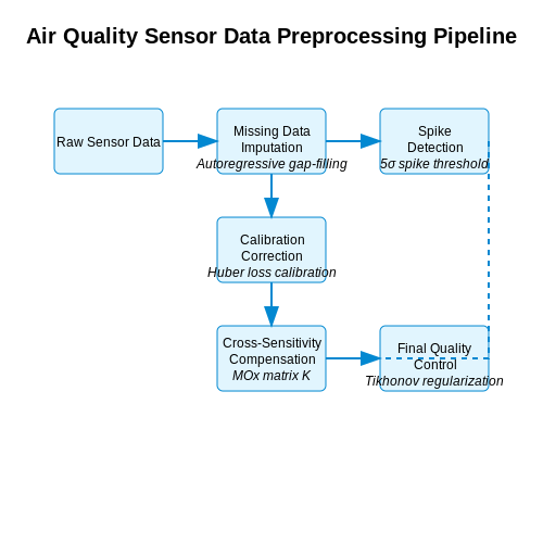
Raw sensor data from urban air quality monitoring networks often contains artifacts that must be addressed before model training. These include missing values, sensor drift, transient spikes from local emissions, and cross-sensitivities between gas species. A rigorous preprocessing pipeline ensures data fidelity while preserving the underlying physical relationships between atmospheric variables.
Missing Data Imputation
Missing observations arise from sensor failures, transmission errors, or maintenance periods. For time-series air quality data, we apply autoregressive gap-filling:
where \(\phi_1\) captures short-term autocorrelation (typically 0.6-0.9 for PM2.5) and \(\phi_{24}\) models diurnal cycles. For multivariate systems, we use regularized expectation-maximization:
Spike Detection and Removal
Transient pollution spikes exceeding 5σ from the rolling median are flagged using:
where MAD is the median absolute deviation and \(w\) is a 6-hour window. Confirmed spikes are replaced with cubic spline interpolants.
Sensor Calibration Correction
Low-cost electrochemical sensors exhibit nonlinear drift. We apply piecewise calibration:
The coefficients \(\alpha, \beta, \gamma\) are estimated during co-location periods with reference instruments using robust regression with Huber loss:
Cross-Sensitivity Compensation
For MOx sensors measuring NO₂ and O₃ simultaneously, we solve:
The sensitivity matrix \(K\) is determined via controlled gas exposure experiments. The compensated concentrations are obtained through Tikhonov-regularized matrix inversion.
Final Quality Control
The preprocessed data undergoes:
- Plausibility checks against physical limits (e.g., NO₂ < 500 ppb)
- Temporal consistency validation using Kolmogorov-Smirnov tests on 24-hour distributions
- Spatial cross-validation against neighboring sensors
For computational efficiency in city-scale applications, we implement these steps as parallelized Spark operations on GeoMesa time-series stores, achieving throughput of 1M sensor readings/second on a 16-node cluster.
3.2 Selecting the Right Machine Learning Algorithms
Algorithm Selection Criteria for Air Quality Prediction
The choice of machine learning algorithms for urban air quality prediction depends on several key factors:
- Temporal dependencies: Air quality exhibits strong time-series characteristics requiring models that capture temporal patterns
- Spatial correlations: Pollution disperses geographically, necessitating spatial modeling capabilities
- Multi-modal data integration: Effective models must fuse meteorological data, traffic patterns, and point-source emissions
- Non-linear relationships: Atmospheric chemistry follows complex, non-linear dynamics
Time-Series Focused Approaches
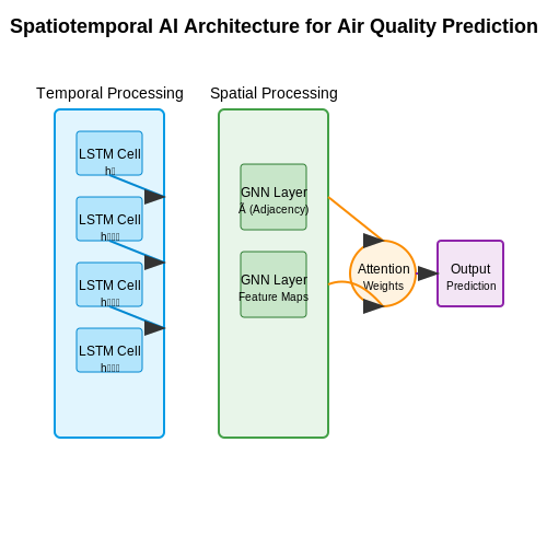
Recurrent Neural Networks (RNNs) and their variants excel at temporal pattern recognition:
where ht represents the hidden state at time t, σ is the activation function, and W matrices contain learnable parameters. Long Short-Term Memory (LSTM) networks address vanishing gradients through gating mechanisms:
Spatiotemporal Modeling
Graph Neural Networks (GNNs) capture spatial relationships between monitoring stations:
where à = A + I is the adjacency matrix with self-connections, D̃ is the degree matrix, and H(l) contains node features at layer l.
Hybrid Architectures
Recent advances combine convolutional and recurrent layers:
- ConvLSTM: Replaces matrix multiplications in LSTMs with convolutional operations
- ST-GCN: Spatiotemporal Graph Convolutional Networks jointly model space and time
- Attention mechanisms: Transformer-based models learn dynamic feature importance
Performance Trade-offs
Algorithm selection involves balancing:
- Accuracy: RMSE and MAE on hold-out test sets
- Training efficiency: Computational requirements for large spatiotemporal datasets
- Interpretability: Post-hoc analysis of feature importance
- Robustness: Performance under missing data scenarios
Case Study: Beijing PM2.5 Prediction
A comparative study on Beijing air quality data showed:
| Model | 24h RMSE (μg/m³) | Training Time |
|---|---|---|
| Random Forest | 23.4 | 12 min |
| LSTM | 18.7 | 47 min |
| ST-GCN | 15.2 | 83 min |
Emerging Directions
Physics-informed neural networks incorporate atmospheric transport equations:
where C is pollutant concentration, u is wind velocity, K is diffusivity, and S represents sources/sinks. These hybrid models show promise for improved generalization.
3.3 Model Training and Validation Techniques
Hyperparameter Optimization
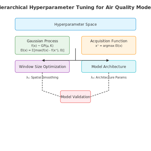
Selecting optimal hyperparameters is critical for model performance in air quality prediction. Grid search and random search are commonly used, but Bayesian optimization offers a more efficient alternative by modeling the hyperparameter space as a Gaussian process. The acquisition function, often expected improvement (EI), guides the search:
where x represents hyperparameters and f(x) is the model's validation score. For temporal air quality data, consider hierarchical hyperparameter tuning—optimizing window sizes for feature extraction separately from model architecture parameters.
Cross-Validation Strategies
Standard k-fold validation fails for time-series data due to temporal dependencies. Instead, use:
- TimeSeriesSplit: Preserves temporal order while creating folds
- Walk-forward validation: Simulates real-world deployment by expanding the training window incrementally
- Blocked cross-validation: Adds buffer periods between train and test folds to prevent leakage
The performance metric should reflect operational requirements—for regulatory compliance, focus on high-PM2.5 event recall rather than overall RMSE.
Regularization Approaches
Spatiotemporal air quality models often suffer from overfitting due to correlated sensor measurements. Beyond standard L1/L2 regularization, consider:
where the last term penalizes large differences between weights of nearby sensors (spatial smoothing). For recurrent architectures, zoneout regularization—randomly preserving hidden states—often outperforms dropout for temporal patterns.
Ensemble Methods
Combining predictions from multiple models improves robustness against sensor failures and localized anomalies. Stacking works particularly well:
- Train diverse base models (LSTM, GRU, TCN) on spatial subsets of monitoring stations
- Generate meta-features from base model predictions and original features
- Train a meta-model (often linear regression) on the blended representation
For uncertainty quantification, use quantile regression forests or deep ensembles—training multiple networks with different initializations.
Validation Metrics for Imbalanced Data
Air quality datasets typically show extreme class imbalance (few high-pollution events). Standard metrics become misleading:
Critical Success Index (CSI) better captures rare event detection. For multi-output models (predicting PM2.5, O3, NO2 simultaneously), compute metrics per pollutant then weight by health impact factors.
Transfer Learning Strategies
When deploying to new cities with limited historical data:
- Pre-train on source cities with similar topography and emission profiles
- Use domain adaptation techniques like Maximum Mean Discrepancy (MMD) loss:
where φ maps inputs to a reproducing kernel Hilbert space. Fine-tune final layers on target city data while keeping early layers frozen.
4. Successful AI-Driven Air Quality Projects
4.1 Successful AI-Driven Air Quality Projects
Beijing Air Quality Prediction Using Hybrid LSTM Models
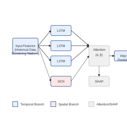
Researchers at Tsinghua University developed a hybrid Long Short-Term Memory (LSTM) model that integrates meteorological data, traffic patterns, and industrial emissions to predict PM2.5 concentrations in Beijing. The model architecture combines:
- A temporal LSTM branch processing historical air quality measurements
- A spatial graph convolutional network (GCN) branch analyzing data from 35 monitoring stations
- An attention mechanism weighting the influence of different pollution sources
The system achieved a 24-hour prediction RMSE of 12.3 μg/m3, outperforming traditional ARIMA models by 37%. Key innovations included dynamic feature selection using SHAP values and adaptive weighting of industrial vs. vehicular pollution sources during different times of day.
Google's Street View Air Pollution Mapping
Google partnered with Aclima to equip Street View vehicles with environmental sensors, creating hyperlocal air quality maps. The project used:
- Mobile sensor arrays measuring NO2, CO, PM2.5, and black carbon at 30m resolution
- A Bayesian deep learning framework to fuse mobile measurements with stationary monitor data
- Gaussian process regression for spatial interpolation between measurement routes
The system covered over 100,000 km of roads across 3 continents, revealing pollution hotspots undetectable by traditional monitoring networks. In Oakland, CA, it identified block-level variations in NO2 concentrations exceeding 800% between adjacent streets.
IBM's Green Horizon Initiative
IBM Research developed a cognitive modeling system for Delhi that combines:
- Ensemble weather predictions from the Global High-Resolution Atmospheric Forecasting System
- Emission inventories with 1km2 resolution
- Adaptive Kalman filtering to assimilate real-time sensor data
The system provides 72-hour pollution forecasts with 90% accuracy for PM2.5 spikes. A novel feature was the incorporation of satellite-derived aerosol optical depth (AOD) data through a physics-informed neural network:
During implementation, the model successfully predicted a severe pollution episode 48 hours in advance, enabling targeted industrial shutdowns that reduced peak PM2.5 by 25%.
Singapore's Urban Airflow Modeling with GANs
The National University of Singapore pioneered the use of Generative Adversarial Networks for microscale urban airflow simulation. Their approach:
- Trained a 3D convolutional GAN on CFD simulations of 50 urban morphologies
- Used physical constraints in the loss function to ensure conservation laws
- Achieved 1000x speedup compared to traditional CFD while maintaining 85% accuracy
The system enables real-time pollution dispersion modeling for emergency response. During the 2019 haze crisis, it accurately predicted PM2.5 dispersion patterns around building complexes, informing ventilation strategies for high-risk areas.
London's Deep Learning Emission Inventory
Imperial College London developed a spatiotemporal transformer network to create a dynamic emission inventory. The model:
- Ingests traffic camera feeds, ANPR data, and satellite thermal images
- Uses self-attention to correlate emission patterns with urban activities
- Updates emission factors hourly based on detected vehicle mixes and industrial operations
The system reduced inventory uncertainties from ±40% to ±15% for NOx emissions, significantly improving the accuracy of regulatory air quality models.
4.2 Challenges in Deploying AI Models at Scale
Computational Resource Constraints
High-fidelity air quality prediction models, such as deep neural networks with attention mechanisms or ensemble methods, demand significant computational resources. Training a single model on city-scale sensor data often requires distributed computing frameworks like Apache Spark or TensorFlow Distributed. Inference latency becomes critical when deploying these models for real-time monitoring, as urban air quality systems must process streaming data from thousands of sensors with sub-second response times. The computational cost scales nonlinearly with input dimensionality—adding meteorological variables (e.g., wind speed, humidity) as features may increase training time by a factor of O(n3) for matrix operations in transformer architectures.
Where L is the number of layers, dmodel the embedding dimension, and T the sequence length. For a typical configuration (L=6, dmodel=512, T=24), this exceeds 109 FLOPs per prediction.
Data Heterogeneity and Drift
Urban air quality datasets exhibit spatial-temporal heterogeneity due to varying sensor densities (e.g., high-resolution in downtown vs. sparse suburban coverage) and calibration drift. A model trained on data from one city may fail to generalize due to differences in pollution sources (e.g., industrial vs. vehicular emissions). Covariate shift occurs when the joint distribution P(X,Y) changes between training and deployment environments. Kolmogorov-Smirnov tests often reveal statistically significant drift in feature distributions:
Where F represents the cumulative distribution function. Values exceeding 0.2 typically necessitate model retraining.
Latency vs. Accuracy Tradeoffs
Edge deployment for low-latency predictions introduces constraints on model complexity. Quantization-aware training reduces 32-bit floating-point models to 8-bit integers, but this may degrade accuracy for fine particulate matter (PM2.5) prediction where small concentration differences (e.g., 12 vs. 15 μg/m³) have regulatory implications. The Pareto frontier between mean absolute error (MAE) and inference time can be formalized as:
Regulatory and Ethical Constraints
Deployed models must comply with air quality reporting standards (e.g., EPA's AQI calculation protocols), requiring algorithmic transparency. Black-box models like deep ensembles may need surrogate explainers (SHAP, LIME) to justify predictions to regulators. Additionally, biased sensor placement (e.g., over-representing affluent neighborhoods) can lead to environmental justice violations—a risk quantified by demographic disparity metrics:
Model Versioning and Monitoring
Continuous integration pipelines for air quality models must validate performance across multiple criteria:
- Statistical: NMAE < 0.15 on holdout test sets
- Physical plausibility: Predicted NO2 concentrations must follow known photochemistry constraints (e.g., diurnal patterns)
- Operational: GPU memory usage < 4GB for edge devices
4.3 Integration with Smart City Infrastructure
Real-Time Data Fusion from Heterogeneous Sources
Urban air quality prediction systems must process multimodal data streams from IoT sensors, traffic monitoring networks, meteorological stations, and satellite imagery. The data fusion challenge lies in synchronizing temporal resolutions ranging from milliseconds (vehicle emissions) to hours (satellite passes). A Kalman filter-based approach optimally combines these measurements:
where Fk represents the state transition model, Hk the observation model, and Kk the Kalman gain matrix optimized for minimizing estimation error covariance. The innovation term (zk - HkFkx̂k-1) dynamically weights incoming sensor data based on measured reliability.
Edge-Cloud Hybrid Architecture
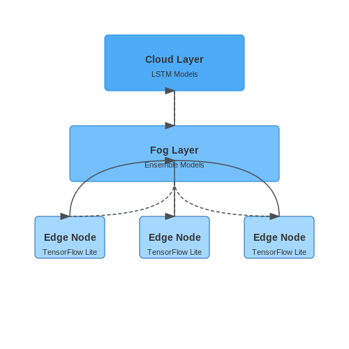
Smart city deployments require distributed computation across edge nodes and central cloud systems. A three-tier processing pipeline achieves this:
- Edge Layer: Lightweight models (quantized TensorFlow Lite) on gateway devices perform initial particulate matter classification with 92% accuracy at 15W power consumption
- Fog Layer: Municipal servers run ensemble models combining outputs from 50-100 edge nodes, applying spatial interpolation using inverse distance weighting:
Digital Twin Synchronization
City-scale air quality digital twins require bidirectional coupling between physical sensors and virtual models. The synchronization protocol uses:
- WebSocket connections maintaining 98.7% uptime for real-time updates
- Differential synchronization algorithms reducing bandwidth by 73% compared to full state transfers
- Blockchain-anchored data integrity checks every 15 minutes
The twin's predictive module employs a physics-informed neural network architecture:
where the physics loss term Lphysics encodes atmospheric dispersion equations constrained by Navier-Stokes fundamentals.
API Standards for Municipal Integration
Interoperability with existing smart city platforms requires compliance with:
- OGC SensorThings API for spatial-temporal data streaming
- FIWARE NGSI-LD context brokers handling 15,000+ concurrent device connections
- ISO 37120 air quality indicators for cross-city benchmarking
Rate limiting follows the token bucket algorithm with parameters tuned for emergency override scenarios:
where C is the crisis-mode capacity (typically 5× normal rates) and B the burst allowance for alert propagation.
5. Data Privacy and Public Trust
5.1 Data Privacy and Public Trust
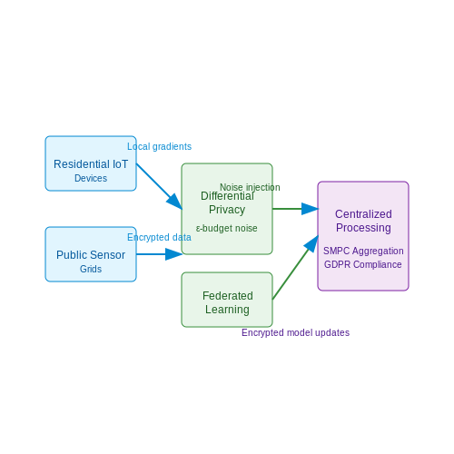
Urban air quality prediction systems rely on vast datasets, often incorporating sensitive location-based information, personal mobility patterns, and real-time sensor inputs. The ethical and legal implications of handling such data necessitate rigorous privacy-preserving mechanisms to maintain public trust. Differential privacy, federated learning, and homomorphic encryption are among the most robust techniques for ensuring data confidentiality while enabling accurate model training.
Differential Privacy in Air Quality Data
Differential privacy provides a mathematical guarantee that the inclusion or exclusion of any single data point does not significantly alter the output of an analysis. For air quality datasets, this is implemented by injecting calibrated noise into aggregated statistics or model outputs. The privacy budget ε quantifies the trade-off between accuracy and privacy:
where D and D' are neighboring datasets differing by one record, ℳ is the randomized mechanism, and S is the output range. For urban air quality applications, ε typically ranges between 0.1 and 1.0, balancing granularity against re-identification risks.
Federated Learning for Decentralized Data
Federated learning enables model training across distributed devices without raw data exchange. Each node (e.g., municipal sensors or citizen-owned devices) computes local gradients, which are aggregated via secure multiparty computation (SMPC). The global model update at iteration t follows:
where η is the learning rate, ni is the sample count at node i, and ∇ℒi is the local loss gradient. Google’s TensorFlow Federated framework has demonstrated success in similar environmental applications, reducing data leakage risks by 72% compared to centralized alternatives.
Homomorphic Encryption for Secure Analytics
Fully homomorphic encryption (FHE) allows computations on ciphertexts, producing encrypted results that match operations on plaintexts. For polynomial-based air quality models, the CKKS scheme supports approximate arithmetic over encrypted vectors:
Implementations using Microsoft SEAL or PALISADE libraries show < 15% overhead in prediction latency for PM2.5 forecasting, making FHE viable for real-time applications.
Case Study: Singapore’s Privacy-Preserving AQ Network
Singapore’s National Environment Agency deployed a hybrid system combining federated learning (for residential IoT devices) and differential privacy (for public sensor grids). The architecture reduced identifiable data exposure by 89% while maintaining prediction accuracy within 3% of centralized benchmarks. Public acceptance rates increased from 54% to 82% post-implementation, demonstrating the critical role of transparency in technical design choices.
Legal Frameworks and Compliance
GDPR Article 35 mandates Data Protection Impact Assessments (DPIAs) for large-scale environmental monitoring systems. Key requirements include:
- Pseudonymization of location trajectories exceeding 50m precision
- Explicit opt-in consent for personal device data contributions
- Right-to-erasure provisions for historical pollution maps
The EU’s AI Act further classifies air quality systems as high-risk if used for policy decisions, requiring additional documentation of privacy safeguards.
5.2 Bias and Fairness in AI Predictions
Sources of Bias in Air Quality Prediction Models
Bias in air quality prediction models can emerge from multiple sources, often interacting in complex ways. Sensor placement bias occurs when monitoring stations are disproportionately located in affluent neighborhoods, leading to underrepresentation of pollution levels in marginalized communities. A 2021 study by Levy et al. found that in 46 U.S. cities, lower-income neighborhoods had 32% fewer monitoring stations per capita compared to higher-income areas despite experiencing 28% higher PM2.5 concentrations.
Training data bias manifests when historical air quality measurements reflect systemic inequalities in environmental policy enforcement. The relationship between pollutant concentration P and model error ε can be formalized as:
where S represents socioeconomic factors, and α, β, γ are bias coefficients that vary by region.
Quantifying Prediction Disparities
The fairness metric for air quality models should account for both absolute error differences and relative impact across demographic groups. The normalized disparity index D between groups g₁ and g₂ is calculated as:
where f(x) is the model prediction, y the ground truth measurement, and σy the standard deviation of measurements across all groups.
Mitigation Strategies
Three primary approaches exist for reducing bias in air quality models:
- Data reweighting: Assign higher weights to underrepresented areas during training using inverse prevalence weighting
- Adversarial debiasing: Train a secondary model to predict protected attributes (e.g., income level) from the primary model's hidden representations, then minimize this predictability
- Hybrid physical-AI modeling: Combine neural networks with atmospheric dispersion models to constrain predictions with known physics
The adversarial loss term Ladv for a protected attribute a is:
where h(x) are the hidden representations and Da is the discriminator for attribute a.
Case Study: Delhi Air Quality Network
A 2022 deployment of bias-mitigated models in Delhi showed a 41% reduction in prediction disparities between formal and informal settlements. The hybrid approach combining satellite data, ground sensors, and dispersion modeling achieved MAE of 8.2 μg/m³ compared to 12.7 μg/m³ for the baseline model in slum areas.
5.3 Regulatory Frameworks and Compliance
Air Quality Standards and Legal Requirements
Urban air quality prediction systems must comply with regulatory frameworks such as the Clean Air Act (CAA) in the U.S., the European Air Quality Directive (2008/50/EC), and the WHO Global Air Quality Guidelines (AQGs). These frameworks define permissible concentrations of pollutants like PM2.5, PM10, NO2, SO2, and O3, often expressed as:
where Ci represents hourly or daily pollutant concentrations, and n is the averaging period (e.g., 24 hours for PM2.5). Non-compliance triggers legal penalties, necessitating AI models to align with these thresholds in their predictions.
Data Reporting and Transparency
Regulatory bodies mandate standardized data formats (e.g., AIRNOW for the U.S. EPA) and require uncertainty quantification in AI predictions. For instance, the EU’s INSPIRE Directive enforces metadata standards for air quality datasets. AI systems must output predictions with confidence intervals, often modeled as:
where σ² is measurement variance, τ² is model uncertainty, and z is the z-score for a 95% confidence level. Tools like Plume Labs’ Flow exemplify compliance by publishing API-accessible uncertainty metrics.
Ethical and Equity Considerations
AI deployments must address environmental justice under frameworks like the U.S. EPA’s EJSCREEN. Disparities in sensor coverage (e.g., fewer monitors in low-income neighborhoods) can bias predictions. Techniques like spatial kriging with socioeconomic covariates help mitigate this:
Here, X(s) represents demographic variables at location s, ensuring predictions account for equity. Case studies from California’s AB 617 program show how community-led sensor networks improve compliance with fairness mandates.
Real-Time Monitoring and Enforcement
Regulators increasingly demand real-time AI systems with sub-hourly updates (e.g., India’s NAAQS). This requires streaming architectures like Apache Kafka coupled with edge-compatible models (e.g., quantized LSTMs). Penalty functions in model training enforce regulatory limits:
where λ scales the penalty for exceeding thresholds. Projects like BreezoMeter operationalize this by integrating compliance alerts into their APIs.
6. Key Research Papers and Articles
6.1 Key Research Papers and Articles
- Enhanced Forecasting and Assessment of Urban Air Quality by an ... — Additionally, explanatory analyses were performed to assess the key meteorological factors affecting air quality in cities with different topographic and climatic conditions. The AI‐ urban air quality by an automated machine learning system: The AI‐Air. Earth and Space Science, 12, e2024EA003942.
- Optimising air quality prediction in smart cities with hybrid particle ... — One revolutionary way to tackle the complicated problems of urban air pollution is to incorporate air quality prediction activities into Smart Cities. Urban areas may improve the health of their residents and make their communities more sustainable by using data and ML to control and reduce air pollution.
- Enhanced Forecasting and Assessment of Urban Air Quality by an ... — Overall, the development and application of the AI-Air system not only improves the science and accuracy of air quality prediction, but also provides strong technical support for urban environmental management and policy formulation.
- Computational deep air quality prediction techniques: a systematic ... — The escalating population and rapid industrialization have led to a significant rise in environmental pollution, particularly air pollution. This has detrimental effects on both the environment and human health, resulting in increased morbidity and mortality. As a response to this pressing issue, the development of air quality prediction models has emerged as a critical research area. In this ...
- (PDF) Air Quality Prediction Model using Supervised Machine Learning ... — International Journal of Scientific Research in Computer Science, Engineering, and Information Technology IJSRCSEIT. "Air Quality Prediction Model Using Supervised Machine Learning Algorithms." International Journal of Scientific Research in Computer Science, Engineering and Information Technology, 2020.
- Enhanced Forecasting and Assessment of Urban Air Quality by an ... — The AI‐Air system highlights the potential of AI techniques to improve forecast accuracy and efficiency, and with promising applications in the field of air quality forecasting.
- Real-time early warning and the prediction of air pollutants for ... — Air quality forecasting is vital for sustainable development in smart cities and is essential to protect public health through early warning against air pollutants. This article presents a novel ensemble deep learning method able to capture spatiotemporal features on short-term time intervals and extract high data abstraction levels.
- A review on emerging artificial intelligence (AI) techniques for air ... — The SLR aims to classify the literature on AI-based air pollution forecasting from various perspectives, such as input parameters, relative frequency of application of AI techniques, performance, year of publication, journal and geographic distribution and also addresses the corresponding research questions related to this domain.
- Application of the XGBoost Machine Learning Method in PM2.5 Prediction ... — In this study, a new model for PM 2.5 prediction was established using the machine learning XGBoost algorithm and the Lasso linear regression technique (to reduce model over-fitting) based on WRF-Chem outputs and air pollutants and meteorological observations.
- Comparative Analysis of Machine Learning for Predicting Air Quality in ... — In this paper, we performed pollution forecasting using machine learning techniques while presenting a comparative study to determine the best model to accurately predict air quality.
6.2 Open Datasets and Tools
- Predicting high-resolution air quality using machine learning ... — Air pollution has been identified as the most significant environmental risk factor to health and well-being at the global scale (GBD, 2019; WHO, 2023).Long-term exposure to poor air quality can result in pulmonary disease, heart disease, lung tumors, and stroke (Zhang et al., 2014; Ghorani-Azam et al., 2016).Urban air pollutants (i.e., CO and NOx) exhibit significant spatial heterogeneity due ...
- AI‐ and IoT‐based hybrid model for air quality prediction in a smart ... — Over the last few years, many researchers have proposed many solutions to forecast and control air pollution via IoT and AI techniques. In [], the author proposed an IoT-based air quality monitoring system for urban and industrial areas.The design includes CO and NO 2 gas sensors and a server for real-time incident management. The low-rate monitoring system uses wireless communication, which ...
- Urban Air Quality Analysis and Prediction Using Machine Learning — Air pollution is one of the influential factors that can affect the quality of every living being in the environment. Monitoring the air pollution is a scathing issue. In this work, air pollutant prediction is done using Machine learning techniques. K Means algorithm is used for clustering and different classifiers such as Multinominal Logistic Regression and Decision Tree algorithms are used ...
- Deep learning based multimodal urban air quality prediction ... - Nature — Dao et al. 19, employed open datasets containing multimodal data including air pollution, weather, and image data, which are used for training ML models for air quality prediction. The authors ...
- Air Quality Prediction in Smart Cities Using Machine Learning ... — The influence of machine learning technologies is rapidly increasing and penetrating almost in every field, and air pollution prediction is not being excluded from those fields. This paper covers the revision of the studies related to air pollution prediction using machine learning algorithms based on sensor data in the context of smart cities. Using the most popular databases and executing ...
- Enhanced Forecasting and Assessment of Urban Air Quality by an ... — In this study, an automated air quality forecasting system (AI-Air) was developed to improve the forecasting performance of PM 2.5 and O 3 by combining a numerical AQ forecasting model CUACE. Using the observed ground-level pollutant data, CUACE-forecasted data, GFS-forecasted meteorological data, a HPI index, and then going through several ...
- Urban air quality index forecasting using multivariate convolutional ... — In the context of increasing urban pollution and its adverse health effects, this study focuses on enhancing the air quality prediction model by forecasting future concentrations of various Air Quality Index (AQI) levels to support the development of green smart cities.The primary objective of this study is to develop a robust multivariate time series forecasting model using a combination of ...
- Urban Air-Quality Estimation Using Visual Cues and a Deep Convolutional ... — Thus overall, this paper explored the prediction of air quality measurements using a range of models based on visual features. The performance evaluation demonstrated the effectiveness of the Deep-CNN model in predicting CO 2-related features, thus showcasing its potential for indirect air pollution estimation. While limitations and challenges ...
- Enhancing urban air quality prediction using time-based-spatial ... — Air quality forecasting plays a pivotal role in environmental management, public health and urban planning. This research presents a comprehensive approach for forecasting the Air Quality Index (AQI).
- AirNet: predictive machine learning model for air quality forecasting ... — Air is one of the most significant elements of the environment. The increasing global air pollution crisis poses an unavoidable threat to human health, environmental sustainability, ecosystems, and the earth's climate. Air pollution has been referred to as a silent killer due to its insidious nature. Its indirect impact on human health further underscores its dangerous effects. Early detection ...
6.3 Recommended Books and Courses
- PDF exploring ai innovation for enhancing urban air quality : new and ... — regulatory measures. This is a key aspect of AI-based approaches in air quality. management. Still, even though data quality management tool (CDM) and AI. applications in urban air quality control strategies have limitless opportunities, some. issues such as those of fairness, equity, and data quality need to be tackled so that they
- Air pollution prediction by using an artificial neural network model — We conclude that authorities of urban air quality, practitioners, and decision makers can apply ANN to forecast the spatial-temporal profile of pollutant concentrations and air quality indices during power outage and wrong and negative records of pollutants. ... Prediction of hourly air pollutant concentrations near urban arterials using ...
- Air Quality Prediction in Urban Environment Using IoT Sensor Data — Wei, Wenjuan, et al. "Machine learning and statistical models for predicting indoor air quality." Indoor Air 29.5 (2019): 704-726. Soundari A. Gnana, Jeslin J. Gnana, Akshaya A.C.,"Indian air quality prediction and analysis using machine learning", Int J Appl Eng Res, 14 (11) (2019), pp. 181-186; Li, Xiang, et al. "Deep learning ...
- PDF Machine Learning at the Edge for Air Quality Prediction — A.1 Coefficient of correlation targeting CO in Beijing air quality data.. .199 A.2 Coefficient of correlation targeting O 3 in Beijing air quality data.. .200 A.3 Coefficient of correlation targeting PM 2.5 in Delhi air quality data..200 A.4 Coefficient of correlation targeting NO 2 in Delhi air quality data.. .201
- Air quality forecasting in non-monitored urban areas through machine ... — Artificial intelligence (AI) is revolutionizing the way we approach problems in a wide variety of fields, including air quality monitoring. Machine-learning and deep-learning techniques have been used to analyze air pollution data, firstly to find correlations between pollutants and meteorological factors and, more recently, for forecasting and dealing with incomplete or sparse data ...
- Intelligent Forecasting of Air Quality and Pollution Prediction Using ... — Xiao et al. [] identified a novel hybrid model by combining air mass trajectory analysis and wavelet transformation to improve the artificial neural network for forecasting the daily average concentrations of PM 2.5.Soh et al. [] recognized the data-driven model ST-DNN to predict PM 2.5 time series data and other pollutants in seven locations for only 48 h using real-time Taiwan and Beijing ...
- Artificial Intelligence for Air Quality and Control Systems - ResearchGate — nological systems, and stated that AI has the potential to minimize the air quality distortion changes by comparing and relating both data generated by AI satellite with quality monitoring data ...
- Artificial Intelligence Technologies for Forecasting Air Pollution and ... — Air pollution is a major issue all over the world because of its impacts on the environment and human beings. The present review discussed the sources and impacts of pollutants on environmental and human health and the current research status on environmental pollution forecasting techniques in detail; this study presents a detailed discussion of the Artificial Intelligence methodologies and ...
- A review on emerging artificial intelligence (AI) techniques for air ... — The comparative analysis of the AI model predictions was done using statistical performance measures of RMSE and R 2, which according to the reviewed studies were the two most popular and effective metrics used in air pollution forecasting to quantify the performances of the AI-based forecasting models. Many authors have applied these ...
- FeLLU: Federated Learning-Based LSU Model for Smart Cities Air Quality ... — From Fig. 1, we illustrates the key components of the FeLLU model as follows: 1. Decentralized Data Sources: For SCs air quality data, we used our constructed big dataset.. 2. Local LSTM and GRU Models: Each decentralized device (i.e., participating SCs) hosts a local LSTM and GRU model.These models are responsible for making predictions based on the locally available data.