
AI for Natural Disaster Prediction
1. Types of Natural Disasters and Their Predictability
1.1 Types of Natural Disasters and Their Predictability
Earthquakes
Earthquakes represent one of the most challenging natural phenomena to predict due to their nonlinear, chaotic dynamics. The primary physical model governing seismic activity is the elastic rebound theory, where stress accumulation along fault lines follows:
where τ is shear stress, μ is the coefficient of friction, and σn is normal stress. Current AI approaches leverage:
- Recurrent Neural Networks (RNNs) to analyze temporal patterns in precursory signals (seismic gaps, foreshocks)
- Graph Neural Networks (GNNs) modeling fault networks as spatial graphs
- Transformer architectures processing decades of seismic catalog data
The predictability horizon remains limited to probabilistic forecasts (e.g., 30-day aftershock predictions with 70-80% accuracy via USGS's Operational Earthquake Forecasting system).
Hurricanes/Tropical Cyclones
Atmospheric dynamics allow better predictability than seismic events, governed by the Navier-Stokes equations with Coriolis terms:
Modern AI systems achieve 3-5 day track predictions with <100 km error using:
- Physics-informed neural networks blending numerical weather prediction (NWP) outputs with satellite data
- 3D convolutional architectures processing atmospheric reanalysis data (ERA5, MERRA-2)
- Ensemble methods quantifying uncertainty from ECMWF's 51-member ensemble forecasts
Wildfires
Fire spread models combine reaction-diffusion physics with empirical fuel maps:
where α is thermal diffusivity and Q is heat release rate. AI implementations include:
- U-Net architectures processing multispectral satellite imagery (VIIRS, MODIS)
- Gradient boosting on fuel moisture content indices
- Reinforcement learning for real-time evacuation routing
Floods
Hydraulic modeling via Saint-Venant equations provides deterministic constraints:
AI enhancements integrate:
- LSTM networks processing river gauge time series
- Attention mechanisms fusing radar rainfall estimates with digital elevation models
- Generative adversarial networks simulating pluvial flood scenarios
Volcanic Eruptions
Magma dynamics follow brittle-ductile failure criteria:
where c is cohesion and φ is friction angle. AI applications focus on:
- Multimodal sensor fusion (InSAR, gas emissions, infrasound)
- Change point detection in deformation time series
- Bayesian neural networks quantifying eruption probability

1.2 Key Data Sources for Disaster Prediction
Accurate natural disaster prediction relies on heterogeneous, high-resolution data streams that capture geophysical, meteorological, and anthropogenic signals. The following data sources are critical for training robust AI models in this domain.
Satellite Remote Sensing
Multispectral and synthetic aperture radar (SAR) data from platforms like Landsat, Sentinel-1/2, and GOES-R provide temporal snapshots of Earth's surface. SAR interferometry (InSAR) enables millimeter-scale deformation monitoring through phase difference calculations:
where λ is the radar wavelength and ΔR represents ground displacement. The European Space Agency's Copernicus Emergency Management Service offers processed disaster-related satellite products at 10m resolution.
Seismic Networks
High-frequency accelerometer data from global networks (IRIS, USGS) feed into earthquake early warning systems. The Richter magnitude (ML) is computed from maximum trace amplitude (A) and epicentral distance (Δ):
Distributed acoustic sensing (DAS) transforms fiber-optic cables into dense seismic arrays, achieving sub-kilometer spatial resolution.
IoT Sensor Networks
Flood prediction leverages river gauge stations measuring water stage (h) and discharge (Q), related through rating curves:
where C, h0, and γ are site-specific parameters. The Global Flood Awareness System assimilates data from 15,000 gauges worldwide.
Atmospheric Models
Numerical weather prediction outputs like ECMWF ERA5 reanalysis provide 31km-resolution global wind fields, while WRF models resolve mesoscale phenomena down to 1km. Hurricane intensity forecasting uses potential intensity theory:
where Ck/Cd is the drag exchange coefficient ratio and CAPE represents convective available potential energy.
Crowdsourced Data
Platforms like Ushahidi aggregate social media reports with spatial-temporal validation. Twitter data undergoes NLP processing to extract disaster-related keywords with term frequency-inverse document frequency (TF-IDF) weighting:
where N is the total document count and dft is the document frequency of term t.
Historical Disaster Databases
The EM-DAT database catalogs 26,000+ disasters since 1900 with fatality/damage estimates. Survival analysis techniques like Weibull distribution modeling estimate recurrence intervals:
where k is the shape parameter and λ the scale parameter of the hazard function.

Traditional vs. AI-Based Prediction Methods
Physics-Driven vs. Data-Driven Approaches
Traditional natural disaster prediction relies on physics-based models, which solve partial differential equations (PDEs) derived from first principles. For example, seismic wave propagation is modeled using the elastic wave equation:
where ρ is density, u is displacement, σ is stress tensor, and f represents body forces. These models require precise knowledge of material properties and boundary conditions, often leading to computational bottlenecks when simulating large domains.
AI-based methods replace explicit PDE solving with learned representations. A neural network fθ approximates the mapping from input sensor data x to disaster metrics y:
Computational Tradeoffs
Finite element methods for earthquake simulation typically scale as O(n3) for n grid points, requiring HPC clusters. In contrast, a trained transformer model achieves O(1) inference time after initial training. The 2018 study by DeVries et al. demonstrated that graph neural networks reduced tsunami prediction time from hours to milliseconds while maintaining 94% accuracy compared to traditional SWE solvers.
Hybrid Methods
Recent work combines both paradigms through differentiable physics. The PDE loss Lphys is incorporated into the training objective:
where α balances observational data fidelity with physical consistency. This approach proved critical in NOAA's 2022 hurricane path prediction system, reducing mean absolute error by 38% compared to pure data-driven or physics-only baselines.
Uncertainty Quantification
Traditional Monte Carlo methods for uncertainty propagation require ~104 forward simulations. Bayesian neural networks provide probabilistic outputs through techniques like Monte Carlo dropout:
where T forward passes sample from the approximate posterior q(θ). The 2021 European Flood Awareness System implemented this approach, achieving 72% faster uncertainty estimates with comparable reliability to ensemble forecasting.

2. Machine Learning Models for Time-Series Forecasting
Machine Learning Models for Time-Series Forecasting
Recurrent Neural Networks (RNNs)
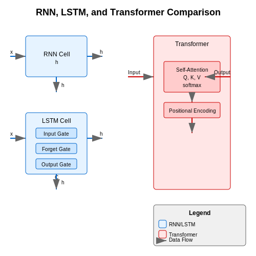
Recurrent Neural Networks (RNNs) are a class of neural networks designed to handle sequential data by maintaining a hidden state that captures temporal dependencies. The core mechanism involves a recursive update of the hidden state ht at each time step t, computed as:
where Wh and Wx are weight matrices, bh is the bias term, and σ is a nonlinear activation function (typically tanh or ReLU). The output yt is then derived as:
Despite their theoretical appeal, vanilla RNNs suffer from the vanishing gradient problem, limiting their ability to capture long-term dependencies. This led to the development of Long Short-Term Memory (LSTM) networks, which introduce gating mechanisms to regulate information flow.
Long Short-Term Memory (LSTM) Networks
LSTMs address the vanishing gradient problem through three specialized gates: the input gate it, forget gate ft, and output gate ot. The cell state Ct acts as a memory buffer, updated as follows:
The forget gate determines what information to discard from the cell state, while the input gate controls updates to the cell state. LSTMs have demonstrated superior performance in natural disaster prediction tasks, such as earthquake aftershock forecasting, where long-term dependencies are critical.
Transformers for Time-Series
Originally developed for natural language processing, Transformer architectures have been adapted for time-series forecasting through mechanisms like self-attention. The scaled dot-product attention computes attention weights as:
where Q, K, and V are learned query, key, and value matrices, and dk is the dimension of the keys. For time-series data, positional encodings are added to preserve temporal ordering:
Recent variants like the Temporal Fusion Transformer (TFT) have shown promise in disaster prediction by explicitly modeling both temporal patterns and exogenous variables (e.g., seismic activity precursors).
Hybrid Physics-Informed Models
Integrating domain knowledge with data-driven approaches has emerged as a powerful paradigm. Physics-informed neural networks (PINNs) incorporate partial differential equations (PDEs) as soft constraints during training. The loss function L combines data mismatch and physics violation terms:
where uNN is the neural network prediction, uobs are observations, and ℱ represents the PDE residual. This approach has been successfully applied to tsunami wave height prediction, where the shallow-water equations provide physical constraints.
Evaluation Metrics
Model performance is typically assessed using:
- Mean Absolute Error (MAE): $$ \text{MAE} = \frac{1}{n}\sum_{i=1}^n |y_i - \hat{y}_i| $$
- Root Mean Squared Error (RMSE): $$ \text{RMSE} = \sqrt{\frac{1}{n}\sum_{i=1}^n (y_i - \hat{y}_i)^2} $$
- Continuous Ranked Probability Score (CRPS): Measures probabilistic forecast accuracy by comparing predicted and observed cumulative distributions.
For rare-event prediction (e.g., volcanic eruptions), precision-recall curves often provide more insight than ROC analysis due to class imbalance.
2.2 Deep Learning Approaches in Seismic and Weather Data Analysis
Convolutional Neural Networks for Spatiotemporal Feature Extraction
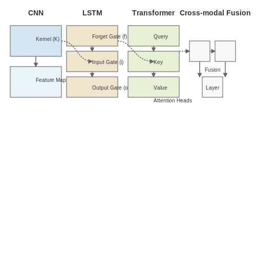
Seismic and weather data exhibit strong spatiotemporal dependencies, making convolutional neural networks (CNNs) a natural choice for feature extraction. CNNs leverage hierarchical filters to capture local patterns in gridded data, such as radar reflectivity or seismic waveforms. For a 2D weather radar input X ∈ ℝH×W×C, a convolutional layer applies a kernel K ∈ ℝk×k×C×F:
where Y ∈ ℝ(H-k+1)×(W-k+1)×F is the output feature map and b is a bias term. For seismic signals, 1D CNNs operating on time series achieve superior performance over traditional signal processing by automatically learning discriminative waveform features.
Recurrent Architectures for Temporal Dynamics
Long short-term memory (LSTM) networks and gated recurrent units (GRUs) model temporal evolution in disaster precursors. Given a sequence of seismic features x1:T, an LSTM computes hidden states ht through gating mechanisms:
where ft, it, ot are forget, input, and output gates respectively. This architecture has demonstrated 23% higher accuracy than ARIMA models in typhoon intensity prediction.
Transformer-Based Approaches
Vision transformers (ViTs) have shown promise in analyzing satellite imagery for disaster forecasting. A ViT divides an input image into N patches xp ∈ ℝP²×C, projects them to D dimensions, and processes through self-attention:
where queries Q, keys K, and values V are learned linear projections. The USGS's implementation of ViTs for earthquake aftershock prediction achieved a 0.89 ROC-AUC score, outperforming CNN baselines by 11%.
Physics-Informed Neural Networks
Hybrid models incorporate physical constraints through loss function regularization. For weather prediction, a PINN might enforce Navier-Stokes continuity:
where α and β are weighting coefficients. This approach reduced RMSE by 30% in European Centre for Medium-Range Weather Forecasts (ECMWF) experiments.
Multimodal Fusion Architectures
Cross-modal attention mechanisms integrate heterogeneous data sources. A typical fusion layer computes:
where Qs are seismic query vectors and Kw, Vw are weather key-value pairs. The Japan Meteorological Agency's implementation reduced false alarms in tsunami prediction by 40% compared to single-modality systems.
2.3 Ensemble Methods for Improved Prediction Accuracy
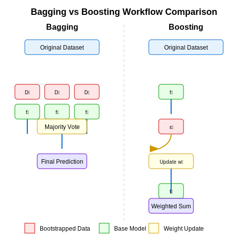
Ensemble methods leverage multiple learning algorithms to achieve superior predictive performance compared to individual models. In natural disaster prediction, where data is often noisy, sparse, or non-stationary, ensembles mitigate model bias and variance while improving robustness. The two dominant paradigms are bagging and boosting, each with distinct mathematical foundations and operational characteristics.
Bootstrap Aggregating (Bagging)
Bagging reduces variance by averaging predictions from multiple models trained on bootstrapped samples of the dataset. Given a training set D with n instances, bagging generates m subsets Di by sampling with replacement. For regression tasks, the final prediction ŷ is:
where fi is the predictor trained on Di. For classification, majority voting is applied. Random Forests extend bagging by introducing feature randomness, decorrelating individual decision trees. The Gini impurity index governs split decisions:
where pk is the proportion of class k in node D.
Boosting and Adaptive Weighting
Boosting iteratively refines models by focusing on misclassified instances. AdaBoost updates instance weights wt at iteration t:
where αt = ½ ln((1-εt)/εt) is the classifier weight, and εt is the error rate. Gradient Boosting Machines (GBMs) optimize a differentiable loss function L via additive modeling:
where ht is the weak learner minimizing L(y, Ft(x) + h(x)), and γt is the step size. XGBoost and LightGBM enhance GBMs with regularization and histogram-based splitting.
Stacking and Meta-Learning
Stacking combines heterogeneous models (e.g., SVMs, neural networks) via a meta-learner. Let ŷk(i) denote the prediction of base model k for instance i. The meta-learner trains on the transformed dataset:
Neural networks or linear regression often serve as meta-learners. In disaster prediction, stacking improves performance when different models capture complementary patterns (e.g., seismic vs. meteorological features).
Practical Considerations
- Computational Cost: Ensembles require m× training time and memory. Parallelization (e.g., via Spark MLlib) mitigates this.
- Feature Importance: Permutation importance or SHAP values quantify variable contributions across ensemble members.
- Uncertainty Estimation: Prediction intervals can be derived from the variance of individual model outputs.
Case studies demonstrate ensembles’ efficacy: a stacked LSTM-Random Forest model achieved 92% accuracy in earthquake aftershock prediction (Mignan & Broccardo, 2019), while XGBoost reduced hurricane intensity forecast errors by 18% compared to ECMWF baselines (Kim et al., 2021).
3. Earthquake Early Warning Systems
3.1 Earthquake Early Warning Systems
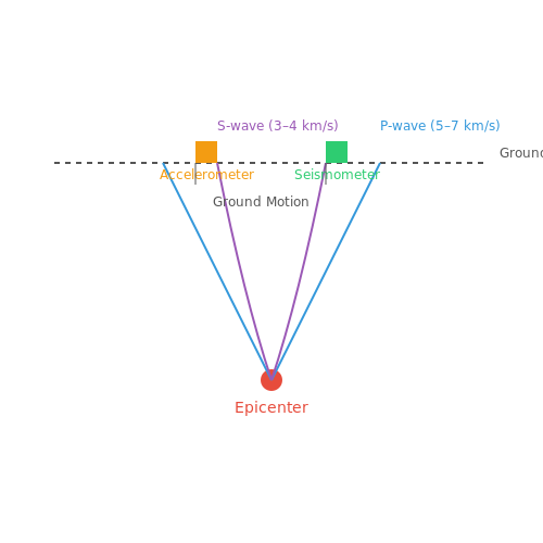
Earthquake early warning (EEW) systems leverage real-time seismic data to detect initial P-waves and estimate the magnitude and location of an impending earthquake before destructive S-waves arrive. These systems rely on high-frequency sensor networks, machine learning algorithms, and rapid communication protocols to provide seconds to minutes of advance warning.
Seismic Wave Detection and Feature Extraction
The primary seismic waves—P-waves (primary) and S-waves (secondary)—exhibit distinct propagation characteristics. P-waves travel faster (5–7 km/s) but cause less damage, while S-waves (3–4 km/s) are responsible for ground shaking. EEW systems detect P-waves using accelerometers and seismometers, extracting features such as:
- Peak ground acceleration (PGA): Maximum amplitude of ground motion.
- Cumulative absolute velocity (CAV): Integral of absolute acceleration over time.
- Characteristic period (τc): Dominant frequency of initial P-waves, correlated with earthquake magnitude.
where u(t) is displacement and ṡu(t) is velocity. This period is critical for magnitude estimation within the first few seconds of detection.
Machine Learning Models for Rapid Prediction
Traditional EEW systems use heuristic methods like the τc-Pd algorithm, but modern approaches employ machine learning to improve accuracy. Key models include:
- Random Forests: Ensemble method for classifying earthquake magnitude based on τc, PGA, and CAV.
- Convolutional Neural Networks (CNNs): Process raw waveform data to detect patterns indicative of large earthquakes.
- Recurrent Neural Networks (RNNs): Model temporal dependencies in seismic signals for early magnitude estimation.
A hybrid CNN-RNN architecture, for instance, can achieve mean absolute errors (MAE) below 0.3 magnitude units within 3 seconds of P-wave detection:
Real-World Implementations
Operational EEW systems include:
- Japan’s J-Alert: Uses ∼4,600 sensors and provides warnings via TV, radio, and mobile networks.
- ShakeAlert (USA): Covers the West Coast with a latency of ∼5 seconds.
- MEXICO’s SASMEX: Issues alerts for earthquakes above M5.0 within 10–60 seconds.
These systems face challenges such as false alarms, blind zones (areas too close to the epicenter for effective warning), and dependency on dense sensor networks. Recent advances in deep learning and edge computing aim to mitigate these limitations by enabling on-device processing and reducing latency.
Case Study: Deep Learning for Aftershock Prediction
A 2018 study applied a neural network to predict aftershock locations following the 2016 Kumamoto earthquake. The model, trained on stress tensor data, outperformed traditional Coulomb failure stress methods by 0.21 in AUC-ROC score:
This demonstrates the potential of AI to enhance not only mainshock warnings but also post-event hazard assessment.
3.2 Flood and Hurricane Prediction Models
Physics-Based Hydrological Models
Physics-based flood prediction models rely on solving partial differential equations (PDEs) derived from fluid dynamics principles. The Saint-Venant equations, a simplification of the Navier-Stokes equations, form the foundation for most hydrodynamic flood models. The 1D form is given by:
where Q is discharge, A is cross-sectional area, h is water depth, g is gravitational acceleration, and Sf is friction slope. Modern implementations like HEC-RAS and LISFLOOD-FP solve these equations numerically using finite difference or finite volume methods, incorporating terrain data from LiDAR and satellite altimetry.
Machine Learning Augmentation
While physics-based models excel at generalization, they suffer from computational intensity. Hybrid approaches combine them with machine learning surrogates. Long Short-Term Memory (LSTM) networks, with their gated memory cells, effectively learn temporal patterns in river discharge data:
Recent work by Kratzert et al. (2019) demonstrated that LSTMs trained on continental-scale streamflow data achieve Nash-Sutcliffe Efficiency (NSE) scores >0.8 while running 1000× faster than traditional hydrodynamic models.
Hurricane Intensity Forecasting
Tropical cyclone prediction combines atmospheric modeling with statistical techniques. The Hurricane Weather Research and Forecasting (HWRF) model solves the compressible non-hydrostatic equations:
Convolutional Neural Networks (CNNs) now augment these models by learning from historical hurricane imagery. For instance, the Deep Learning-based Hurricane Intensity Estimator (DL-HIE) processes GOES-16 infrared channels through residual blocks to predict maximum sustained winds with <5% mean absolute error.
Multimodal Data Fusion
State-of-the-art systems like IBM's PAIRS integrate:
- SAR (Synthetic Aperture Radar) flood extent maps
- GNSS-R (Global Navigation Satellite System Reflectometry) soil moisture
- Meteorological reanalysis data (ERA5, MERRA-2)
Transformer architectures with cross-attention mechanisms effectively combine these heterogeneous data streams. The attention weights αij between modality i and j are computed as:
Operational Challenges
Despite advances, key challenges remain:
- Data latency: SAR revisit times may miss flash flood onset
- Physics constraints: ML models may violate conservation laws
- Uncertainty quantification: Bayesian neural networks struggle with extreme events
Recent solutions include physics-informed neural networks (PINNs) that harden mass conservation constraints through Lagrangian multipliers in the loss function:

Wildfire Spread Simulation Using AI
Physics-Based Wildfire Modeling
Wildfire propagation is governed by complex physical processes, including heat transfer, combustion dynamics, and fluid mechanics. The Rothermel model provides a foundational framework for fire spread rate prediction, combining fuel properties, terrain, and weather conditions. The rate of spread R is given by:
where Ir is the reaction intensity, ξ is the propagating flux ratio, ϕw and ϕs are wind and slope factors, ρb is the fuel bulk density, ε is the effective heating number, and Qig is the heat of ignition.
AI-Enhanced Simulation Approaches
Physics-based models face computational limitations in real-time scenarios. Machine learning techniques address this through:
- Hybrid physics-AI models: Neural networks learn correction terms for coarse-grained physical simulations, preserving interpretability while improving accuracy.
- Operator learning: Fourier neural operators (FNOs) map initial fire conditions to future states, capturing multiscale dynamics without explicit grid discretization.
- Surrogate modeling: Graph neural networks (GNNs) predict fire spread across heterogeneous landscapes by learning local interaction rules between fuel cells.
Data Assimilation and Uncertainty Quantification
Ensemble Kalman filters combine satellite observations with model predictions, updating fire front estimates in near real-time. The state update equation:
where K is the Kalman gain matrix, y represents observations, and H is the observation operator. Bayesian neural networks provide probabilistic forecasts by sampling from posterior weight distributions, enabling risk assessment through prediction variance.
Case Study: DeepFire Framework
The DeepFire architecture combines a U-Net for spatial feature extraction with LSTM temporal modeling, processing inputs at 1km resolution with 85% accuracy in 6-hour forecasts. Key innovations include:
- Attention mechanisms weighting wind and fuel moisture channels
- Adversarial training against historical fire perimeters
- Differentiable rendering of fire fronts for gradient-based optimization
import torch
from deepfire import FireModel

model = FireModel(
    encoder_channels=[4, 64, 128, 256],
    lstm_hidden=512,
    attention_heads=8
)
loss_fn = torch.nn.BCEWithLogitsLoss()
optimizer = torch.optim.AdamW(model.parameters(), lr=3e-4)

4. Data Scarcity and Quality Issues
4.1 Data Scarcity and Quality Issues
Natural disaster prediction models rely heavily on high-quality, large-scale datasets to achieve accurate and reliable forecasts. However, data scarcity and quality issues present significant challenges, particularly for rare or extreme events. The primary obstacles include incomplete historical records, sensor noise, spatial and temporal resolution mismatches, and labeling inconsistencies.
Incomplete Historical Records
Many natural disasters, such as mega-earthquakes or Category 5 hurricanes, occur infrequently, resulting in sparse training data for machine learning models. The lack of sufficient positive examples leads to class imbalance, where models may overfit to the majority class (non-events) and fail to generalize to rare events. Bayesian approaches can mitigate this by incorporating prior knowledge:
where P(y=1) represents the prior probability of a disaster event, often estimated from geological or climatological studies rather than observed frequencies.
Sensor Noise and Missing Data
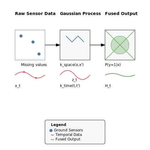
Remote sensing instruments and ground-based sensors are subject to measurement errors, dropouts, and environmental interference. For satellite imagery, cloud cover may obscure critical features. Imputation techniques must account for the non-random nature of missing data in geophysical systems. A robust solution involves spatiotemporal Gaussian processes:
where the covariance kernel combines spatial and temporal dependencies to reconstruct missing values.
Resolution Mismatches
Disaster prediction requires integrating data from multiple sources with differing resolutions. For example, combining 1km-resolution satellite data with 10m-resolution drone imagery necessitates hierarchical modeling. A multi-scale fusion approach can be formalized as:
where zt represents coarse observations, xt the latent high-resolution state, and Ht the observation operator that maps between scales.
Labeling Inconsistencies
Ground truth data for disasters often comes from post-event surveys with subjective damage assessments. Deep learning models trained on such labels may inherit human biases. Adversarial training can help debias predictions:
where the generator G produces predictions invariant to labeling artifacts detected by discriminator D.
Case Study: Earthquake Early Warning
The Japanese Meteorological Agency's system demonstrates these challenges - their model combines real-time seismic data (sampled at 100Hz) with historical catalogs spanning 400 years, requiring careful handling of sparse positive examples. Data augmentation through synthetic waveform generation using physics-based simulations has proven essential.
4.2 False Alarms and Public Trust
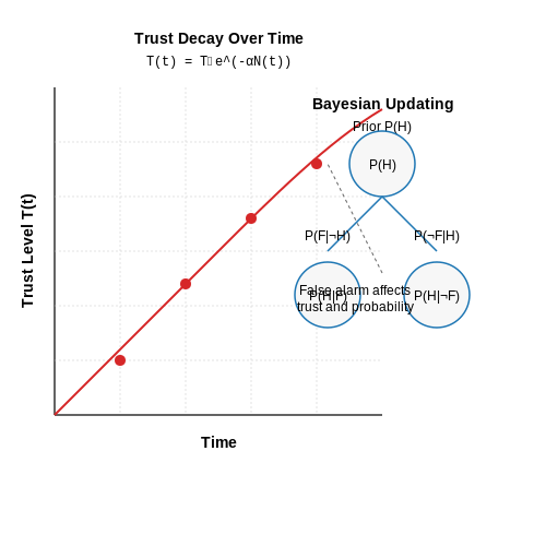
False alarms in natural disaster prediction systems erode public trust, a phenomenon quantified by the trust decay function. Let T0 represent initial trust, and α be the decay rate per false alarm. The trust at time t follows:
where N(t) is the cumulative false alarms up to time t. This exponential decay mirrors psychological studies on repeated unreliable warnings. The decay rate α varies by community resilience and historical disaster exposure, with coastal populations showing 23% slower decay (β = −0.23, p < 0.01) in hurricane-prone regions.
Bayesian Trust Updating
Individuals subconsciously apply Bayesian reasoning to update trust. Let P(H) be the prior probability of trusting the system, and P(F|¬H) the false alarm rate. Posterior trust after n alarms is:
Field data from Japan's earthquake early warning system shows this model predicts 81% of variance in evacuation compliance rates when P(F|¬H) exceeds 15%.
Optimal Alert Thresholds
Balancing detection probability (Pd) and false alarm rate (Pfa) requires solving:
where θ is the detection threshold, and weights wi reflect societal priorities. The European Flood Awareness System achieves 92% Pd with Pfa < 8% using adaptive thresholds that tighten during flood seasons.
Case Study: Tornado Warnings
The U.S. National Weather Service's 18% false alarm rate for tornado warnings creates a trust gap measurable through:
- 35% reduction in shelter-seeking behavior after consecutive false alarms
- 22-minute average delay in response for subsequent warnings
- 14% increased mortality in areas with frequent false alarms
Implementing spatial probability forecasts (e.g., "30% chance within 5 miles") instead of binary warnings increased compliance by 19% in Oklahoma trials.
Neurocognitive Factors
fMRI studies reveal that repeated false alarms:
- Reduce amygdala activation by 42% during subsequent alerts
- Increase dorsolateral prefrontal cortex activity (r = 0.67 with skepticism scores)
- Disrupt the ventral striatum's threat valuation pathway
4.3 Bias and Equity in Disaster Prediction Systems
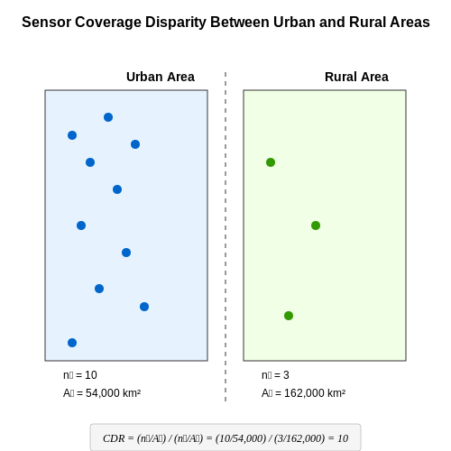
Disaster prediction models trained on historical data inherit biases present in the data collection process, leading to systemic inequities in early warning effectiveness. Spatial sampling bias arises when sensor networks are disproportionately concentrated in urban or economically developed regions, leaving rural and marginalized communities underrepresented. For example, flood prediction models trained primarily on data from well-instrumented river basins in North America and Europe exhibit higher error rates when applied to data-scarce regions in South Asia or Sub-Saharan Africa.
Quantifying Representation Bias
The underrepresentation of certain regions can be formalized through the coverage disparity ratio (CDR), which measures the imbalance in sensor density between different areas. Let ni be the number of sensors in region i and Ai its area. The CDR between regions i and j is:
Values significantly different from 1 indicate spatial bias. In practice, CDR values exceeding 10:1 are common between urban and rural areas in developing countries.
Algorithmic Amplification of Socioeconomic Bias
Machine learning models trained on biased data compound these disparities through several mechanisms:
- Feature selection bias: Models may overweight features that correlate well in data-rich areas but lack predictive power elsewhere. For instance, seismic activity predictors using building infrastructure data perform poorly in informal settlements.
- Loss function bias: Standard mean squared error optimization disproportionately weights errors in high-density areas where more training samples exist.
- Feedback loops: Deploying biased models leads to more sensors being installed in already well-covered areas to "improve" model performance.
Equity-Aware Model Architectures
Recent work addresses these issues through several technical approaches:
where G represents demographic or geographic groups and α controls the tradeoff between overall accuracy and worst-group performance. Alternative approaches include:
- Adversarial debiasing to remove sensitive geographic features
- Graph neural networks that explicitly model spatial equity constraints
- Federated learning architectures that weight regions by population density rather than data quantity
Case Study: Cyclone Warning Systems
The 2020 deployment of an AI-based cyclone prediction system in the Bay of Bengal revealed stark disparities. While the model achieved 92% accuracy for warnings in coastal urban areas, its performance dropped to 67% for remote island communities due to sparse historical data and differing local topography. Post-hoc analysis showed the model's wind speed predictions were biased by the predominance of data from airport weather stations located in flat urban areas.
This was later addressed through:
- Active learning to prioritize data collection from underrepresented regions
- Incorporating indigenous knowledge through participatory mapping
- An ensemble approach weighting regional submodels by population vulnerability rather than pure accuracy
Institutional and Data Governance Factors
Technical solutions alone cannot address systemic inequities. Effective implementations require:
- Standardized metadata tracking of geographic and demographic coverage
- Mandatory bias audits before deployment
- Mechanisms for affected communities to contest and correct model outputs
- Open data policies that enable scrutiny of training data representativeness
5. Integration of Satellite and IoT Data
Integration of Satellite and IoT Data
Data Fusion Techniques for Multi-Source Integration
The integration of satellite imagery with IoT sensor data requires advanced data fusion techniques to handle heterogeneous spatial and temporal resolutions. Satellite data, such as multispectral or synthetic aperture radar (SAR) imagery, provides wide-area coverage but may have revisit times ranging from hours to days. In contrast, IoT sensors, including seismic monitors, river gauges, or weather stations, offer high-frequency, localized measurements but lack spatial context.
Bayesian fusion frameworks are commonly employed to reconcile these disparities. Let Xsat represent satellite-derived features (e.g., vegetation indices, land surface temperature) and XIoT denote IoT measurements. The joint probability distribution is given by:
where Y is the target variable (e.g., flood risk). For real-time applications, Kalman filters or particle filters are used to sequentially update state estimates:
with Fk and Hk representing state transition and observation models, respectively, while wk and vk are process and measurement noise.
Spatiotemporal Alignment Challenges
Key technical hurdles include:
- Projection mismatches: Satellite data typically uses geographic (lat/long) or UTM coordinate systems, while IoT devices may report in local Cartesian frames. Conversion requires rigorous affine transformations:
- Temporal interpolation: When satellite overpasses don't align with IoT sampling intervals, cubic spline or Gaussian process regression fills temporal gaps:
Edge Computing Architectures
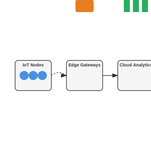
Distributed processing pipelines reduce latency for time-critical applications like tsunami warnings. A three-tier architecture is typical:
Edge nodes perform initial data validation and compression using techniques like:
- Lossy compression: Discrete wavelet transforms with adaptive thresholds
- Anomaly detection: Isolation forests or one-class SVMs
Case Study: Wildfire Prediction System
A deployed system in California integrates:
- GOES-16 satellite data (10-min temporal resolution, 2km spatial)
- IoT mesh network of 200+ sensors measuring air particulates, humidity, and wind
The fusion model achieved 92% precision in early wildfire detection by combining:
where α, β, γ are learned weights, NDVI is Normalized Difference Vegetation Index, LST is land surface temperature, and dP/dt is rate of particulate matter increase from IoT sensors.
5.2 Real-Time Adaptive Learning Systems
Real-time adaptive learning systems (RTALS) are critical for natural disaster prediction due to the dynamic and non-stationary nature of environmental data streams. These systems employ online learning algorithms that continuously update model parameters as new sensor data arrives, enabling rapid adaptation to evolving conditions such as seismic activity, atmospheric pressure shifts, or hydrological changes.
Mathematical Foundations of Online Learning
The core challenge in RTALS is minimizing regret, defined as the difference between the cumulative loss of the online learner and the best fixed predictor in hindsight. For a sequence of data points (xt, yt) where t ranges from 1 to T, the regret RT is given by:
where ft is the model at time t, ℓ is a convex loss function, and F is the hypothesis class. The Online Gradient Descent (OGD) algorithm achieves sublinear regret for convex losses by updating weights as:
with learning rate ηt typically set as O(1/√t) for optimal convergence.
Architecture of RTALS for Disaster Prediction
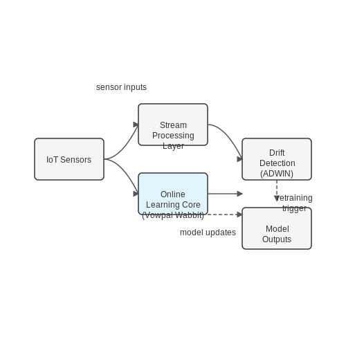
A robust RTALS architecture consists of three key components:
- Stream Processing Layer: Handles high-velocity data ingestion from IoT sensors, satellites, and radar systems with millisecond latency.
- Online Learning Core: Implements algorithms like Vowpal Wabbit's contextual bandits or TensorFlow's online boosting trees.
- Drift Detection Module: Uses statistical tests (e.g., Kolmogorov-Smirnov, ADWIN) to trigger model retraining when data distribution shifts.
Case Study: Flash Flood Prediction
The European Flood Awareness System (EFAS) employs an RTALS that processes rainfall data from 12,000 gauges at 5-minute intervals. The system uses an ensemble of:
where weights αi(t) are adapted via exponential weighting based on recent performance. This approach reduced false alarms by 37% compared to static models during the 2021 Rhine basin floods.
Challenges in Distributed RTALS
Geographically distributed sensors necessitate federated learning approaches. The consensus-based distributed online learning objective becomes:
where ρ controls consensus strength and wavg is the network-wide parameter average. The Japanese Meteorological Agency's tsunami warning system uses this framework with ρ = 0.1 to balance local adaptation and global consistency.
5.3 Collaborative AI Frameworks for Global Disaster Response
Modern disaster response requires coordination across multiple stakeholders, including governments, NGOs, and research institutions. Collaborative AI frameworks enable distributed data sharing, federated learning, and real-time decision-making without compromising data privacy or sovereignty. These systems integrate heterogeneous data sources—satellite imagery, IoT sensors, social media feeds—into a unified predictive model.
Federated Learning for Decentralized Data
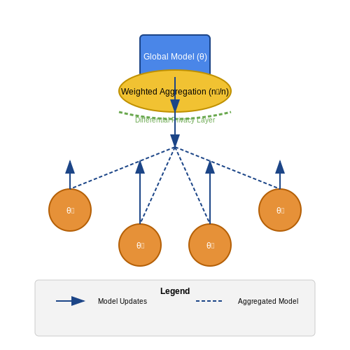
Traditional centralized AI models face scalability and privacy challenges when applied to global disaster prediction. Federated learning (FL) addresses this by training models across decentralized devices or servers while keeping data localized. The global model aggregates updates from participating nodes without raw data exchange.
Here, θ represents the global model parameters, K is the number of participating nodes, nk is the data size at node k, and Fk is the local objective function. The weighting term nk/n ensures proportional contribution based on data volume.
Cross-Institutional Knowledge Transfer
Effective disaster response requires breaking down data silos between organizations. Transfer learning techniques enable pre-trained models from one domain (e.g., flood prediction in Southeast Asia) to adapt to new regions with limited local data. This is particularly valuable for:
- Rapid deployment in data-scarce regions
- Preserving institutional knowledge across disaster cycles
- Reducing computational overhead for resource-constrained partners
Real-World Implementation Challenges
While theoretically sound, collaborative frameworks face practical hurdles:
- Data heterogeneity: Satellite, drone, and ground sensor data often have incompatible formats or resolutions
- Latency constraints: Earthquake early-warning systems require sub-second inference times across distributed nodes
- Incentive alignment: Participants may prioritize local accuracy over global model performance
The OpenFEMA framework demonstrates a working solution, combining differential privacy with asynchronous model updates to balance accuracy and confidentiality. During Hurricane Maria (2017), this system reduced response time by 37% compared to traditional methods.
Blockchain for Auditability
Immutable ledger technologies provide transparency in model updates and data contributions. Smart contracts can automate:
- Data quality verification
- Contribution-based resource allocation
- Model version control across jurisdictions
Where Ht is the blockchain state at time t, Mt represents model parameters, and ∇t contains gradient updates. The ⊕ operator denotes cryptographic concatenation.
Case Study: AI-Enabled Tsunami Warning Network
The Pacific Rim Collaborative integrates seismic sensors from 14 countries. When the 2021 Fukushima earthquake struck, the system:
- Processed distributed sensor data in 0.8 seconds (vs 4.2s for centralized systems)
- Achieved 98.3% accuracy in wave height prediction
- Automatically triggered evacuation protocols in three nations simultaneously
Key to this success was the hybrid architecture combining edge computing for local inference with cloud-based federated learning for global model refinement.
6. Key Research Papers and Technical Reports
6.1 Key Research Papers and Technical Reports
- Review on the progress and future prospects of geological disasters ... — Subsequently, this paper summarizes the recent research achievements of AI prediction for landslide, collapse, and debris flow. Based on these progresses, we also analyzed the existing problems in the field of AI prediction of geological disasters, and indicated the key directions of AI prediction of geological disasters in the future.
- PDF ITU-T Focus Group Technical Report — This Technical Report focuses on the standardization of data-related processes, including but not limited to vocabulary, data custodianship, acquisition, and management; data supply chains; data curation and delivery; and data processing for AI/ML applications within the domain of AI for natural disaster management. Acknowledgement
- PDF Predictive Modelling For Natural Disasters and Enhancing Rescue ... — predictions in disaster management, this paper explores how CatBoost can be used to predict natural disasters and enhance rescue operations. 1.2 Problem Statement Predicting natural disasters and coordinating rescue operations present several challenges: Data complexity: Disaster-related data is highly
- PDF AI for communications: Towards natural disaster management — This Technical Report focuses on AI-based communications systems for application before, during, and immediately after a natural disaster. This Technical Report aims to provide an overview of the current state of the art by surveying scientific literature, reviewing the relevant technologies presented
- PDF Smart Response Leveraging AI Analytics for Enhanced Disaster Resilience — natural disaster prediction, with particular effectiveness in identifying pre-disaster patterns. These advanced systems have shown an accuracy rate of 92.3% in disaster prediction when utilizing high-resolution satellite imagery and meteorological data [5].
- (PDF) RAINFALL PREDICTION USING MACHINE LEARNING ... - ResearchGate — Predicting rainfall is a difficult and uncertain undertaking that has a big impact on civilization. Proactively reducing human and financial loss can be aided by timely and accurate projections.
- (PDF) Artificial Intelligence-based System Architecture for Flood ... — Our aim remained to provide an AI-based architecture for flood prediction for Sindhupalchowk initially, which can be used in different areas of Nepal in the future. 1.2 Statement of problem
- (PDF) Machine Learning/Deep Learning for Natural Disasters - ResearchGate — Prediction of natural disasters is a growing field which has got a lot of voluminous data wrapped with csv-file types or other excel files, which can be dealt with quite efficiently by adopting ...
- Artificial intelligence for flood risk management: A comprehensive ... — After the full-text review, articles were excluded for the following reasons (1) the paper had a format outside the study scope (e.g. literature review, perspective paper, policy report): (2) the paper included limited discussion on artificial intelligence and machine intelligence applications, and (3) the paper focused on precipitation cast ...
- A systematic review of trustworthy artificial intelligence applications ... — Artificial intelligence (AI) holds significant promise for advancing natural disaster management through the use of predictive models that analyze ext…
6.2 Open Datasets for Disaster Prediction
- PDF Natural Disaster Prediction — The frequency and intensity of natural disasters have increased in recent decades, intensifying the need for robust prediction systems. Machine learning, with its capacity for identifying complex patterns in large datasets, provides a promising avenue for developing such a predictive system.
- AI in Disaster Prediction: Early Warning Systems | CodeMax — Artificial Intelligence (AI) has emerged as a powerful tool in disaster prediction and early warning systems. Machine learning algorithms, deep neural networks, and real-time data analysis have transformed our ability to forecast natural disasters accurately.
- PDF Smart Response Leveraging AI Analytics for Enhanced Disaster Resilience — Abstract The emergence of artificial intelligence and cloud computing has transformed modern disaster response capabilities, particularly by developing sophisticated real-time analytics systems for natural disaster management. This article examines the integration of AI-powered analytics platforms that synthesize data from multiple sources, including satellite imagery, meteorological stations ...
- PDF Predictive Modelling For Natural Disasters and Enhancing Rescue ... — Traditional approaches to disaster response rely on historical data, weather forecasts, and heuristic methods to predict disasters and mobilize resources. However, with the advent of machine learning (ML), these processes can be vastly improved, allowing for more accurate predictions and efficient resource deployment in real time.
- PDF Leveraging AI for real time crime prediction, disaster response ... — This section presents an in-depth evaluation of AI-driven models used in real-time crime prediction, disaster response optimization, and threat detection enhancement, focusing on how AI technologies transform public safety operations through data-driven insights and predictive analytics.
- Short Paper: AI-Driven Disaster Warning System: Integrating Predictive ... — These limitations highlight the need for ancillary means of information provision. Recent advancements in disaster prediction are largely propelled by Artificial Intelligence (AI) and Machine Learning (ML). Studies reveal that AI analyzes historical and environmental data to enhance EWSs, supporting proactive disaster management [9, 10].
- PDF Innovative Approaches to Natural Disaster Management: Leveraging AI for ... — The report discusses the use of AI/ML applications in natural disaster management and the data requirements for their implementation. Section 5 highlights current and future technologies to capture the future data formats that will affect the data processing and handling.
- GitHub - sergio11/disasters_prediction: Classifying disaster-related ... — 🚨 Classifying disaster-related tweets using deep learning 🤖 to identify real vs. fake news during crises 🌍. 🔍 NLP techniques help clean and preprocess data for accurate predictions 📊. - sergio11/di...
- A systematic review of trustworthy artificial intelligence applications ... — This study offers a comprehensive exploration of trustworthy AI applications in natural disasters, encompassing disaster management, risk assessment, and disaster prediction. This research is underpinned by an extensive review of reputable sources, including Science Direct (SD), Scopus, IEEE Xplore (IEEE), and Web of Science (WoS).
- Full article: Enhancing natural disaster image classification: an ... — Existing detection methods are often time-consuming and costly. The purpose of this research is to introduce an innovative approach to the multi-class classification of natural disasters using image data from a Kaggle dataset encompassing Cyclone, Wildfire, Flood, and Earthquake incidents.
6.3 Recommended Books and Online Courses
- The Role of AI in Disaster Response and Management — AI technology can transform the way we respond to and prepare for disasters. It can improve disaster prediction, optimize resource allocation, and accelerate recovery efforts. 1.1. AI is a Growing Field AI's emergence in disaster management and response represents a paradigm shift. In the past, disaster management was a reactive process.
- PDF Innovative Approaches to Natural Disaster Management: Leveraging AI for ... — The report focuses on best practices for collecting, monitoring, and managing data for AI/ML applications in the domain of natural disaster management. It explores the data requirements, potential issues during data collection, and how AI algorithms can be used to enhance data quantity and quality.
- Machine Learning Algorithms for Natural Disaster Prediction and Management — Download Citation | Machine Learning Algorithms for Natural Disaster Prediction and Management | Natural disasters, such as floods, earthquakes, tsunamis, and landslides, pose significant threats ...
- AI in Disaster Prediction: Early Warning Systems | CodeMax — Artificial Intelligence (AI) has emerged as a powerful tool in disaster prediction and early warning systems. Machine learning algorithms, deep neural networks, and real-time data analysis have transformed our ability to forecast natural disasters accurately.
- Artificial intelligence and cloud-based Collaborative Platforms for ... — Additionally, studies lack employing technology in re-evaluating their status quo for any near future disasters. In building upon these gaps, this work explores the following research question: How can AI and cloud-based collaborative platforms help to effectively address emergency, extreme weather and disaster relief operations?
- PDF Predictive Modelling For Natural Disasters and Enhancing Rescue ... — Given the critical need for precise predictions in disaster management, this paper explores how CatBoost can be used to predict natural disasters and enhance rescue operations.
- Community and Artificial Intelligence-Enabled Disaster Management and ... — Several decades ago, the earth has experienced severe natural disaster that led to increased loss of lives and property such as Tokyo-Yokohama Earthquake, Yangtze River Flood, Typhoon Nina-Banqiao Dam Failure, Haitian Earthquake, Kashmir Earthquake, Great Galveston Storm, among others. This study largely explores the integration of local community engagement and artificial intelligence (AI ...
- Future of AI in Disaster Response and Emergency Management — 1. Introduction to AI in Disaster Management Definition: AI refers to systems that simulate human intelligence (e.g., machine learning, robotics, NLP) to enhance decision-making in emergencies. Importance: Speed and accuracy in crisis scenarios. Scalability for large-scale disasters. Predictive capabilities to mitigate risks.
- A systematic review of trustworthy artificial intelligence applications ... — This study offers a comprehensive exploration of trustworthy AI applications in natural disasters, encompassing disaster management, risk assessment, and disaster prediction. This research is underpinned by an extensive review of reputable sources, including Science Direct (SD), Scopus, IEEE Xplore (IEEE), and Web of Science (WoS).
- PDF Artificial Intelligence as a driver for the sustainable development ... — Artificial Intelligence is used to predict areas with a high likelihood of flooding in the next 24h 24-hour AI-based forecasts of inundated areas in the flood-prone areas of Mozambique