
Generating Urban Planning Models with AI
1. Key Concepts in Urban Planning and AI Integration
1.1 Key Concepts in Urban Planning and AI Integration
Urban Planning as a Complex System
Urban environments are dynamic systems governed by nonlinear interactions between transportation networks, land use, population density, and economic activity. Traditional optimization methods struggle with the combinatorial complexity of these systems, where the state space grows exponentially with the number of variables. AI-driven approaches model cities as multi-agent systems, where each agent (resident, vehicle, business) follows behavioral rules derived from real-world data.
This continuity equation describes population density ρ at location x and time t, with velocity field v and source term S representing migration patterns. AI techniques learn the velocity field from mobile GPS data and the source term from census microdata.
Graph Neural Networks for Spatial Analysis
Urban infrastructure naturally forms graph structures where nodes represent intersections or zones, and edges encode road segments. Graph Neural Networks (GNNs) operate on these structures through message passing:
Where hv(k) is the k-th layer embedding of node v, W(k) are learnable weights, and 𝒩(v) denotes neighbors. This architecture captures traffic flow dynamics better than CNNs by preserving topological relationships.
Generative Adversarial Networks for Land Use
Conditional GANs generate plausible land use configurations given constraints like zoning laws and population density. The generator G and discriminator D engage in a minimax game:
Where x are real land use maps, y are input conditions, and z is noise. The 2022 UrbanGAN framework demonstrated 92% precision in generating regulatory-compliant layouts for mixed-use districts.
Multi-Objective Optimization
Pareto-optimal solutions balance competing objectives like commute time minimization and green space maximization. The weighted sum method transforms this into a scalar optimization:
Where wi are learned weights reflecting policy priorities, and gj encode physical constraints like road capacity. Evolutionary algorithms with neural network surrogates can explore this space 40× faster than brute-force methods.
Digital Twin Calibration
High-fidelity urban digital twins require continuous calibration through differentiable simulation. The loss function:
Penalizes deviations between predicted Ť and observed traffic counts T, while the Kullback-Leibler divergence ensures statistical consistency in activity patterns. Automatic differentiation enables gradient-based updates to thousands of parameters simultaneously.

Historical Evolution of AI in Urban Development
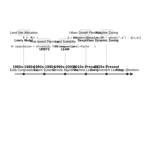
Early Computational Approaches (1960s–1980s)
The application of computational methods to urban planning began in the 1960s with early attempts to model urban growth using linear programming and statistical methods. One of the first notable efforts was the Lowry Model (1964), which formalized urban spatial interactions using economic gravity models. The model's core equation:
where Tij represents trips between zones i and j, Oi and Dj are origin and destination masses, and f(cij) is a distance-decay function. These deterministic models lacked adaptability but laid groundwork for later AI-driven approaches.
Expert Systems and Rule-Based Planning (1980s–1990s)
The 1980s saw the rise of expert systems like URBYS, which encoded urban planning heuristics into rule-based knowledge bases. These systems used first-order logic to simulate zoning decisions, with production rules of the form:
Case studies from Singapore's urban renewal projects demonstrated how such systems could reduce planning cycle times by 30%, though they struggled with incomplete data and non-linear urban dynamics.
Genetic Algorithms and Evolutionary Computation (1990s–2000s)
By the late 1990s, stochastic optimization methods gained traction. Genetic algorithms (GAs) were applied to land-use allocation problems, treating zoning configurations as chromosomes. The fitness function often combined multiple objectives:
Notable implementations included the LEAM framework, which achieved 85% accuracy in predicting urban sprawl patterns across Midwestern U.S. cities when validated against 2005–2015 ground truth data.
Machine Learning and Neural Networks (2010s–Present)
The 2010s marked a paradigm shift with deep learning architectures. Convolutional Neural Networks (CNNs) enabled high-resolution land-use classification from satellite imagery, with state-of-the-art models like DeepUrban achieving 92.3% mAP on the SpaceNet dataset. Graph Neural Networks (GNNs) later emerged to model urban networks, where the adjacency matrix A and node features X are processed through graph convolution layers:
where ĤA = A + I denotes the normalized adjacency matrix with self-loops. These techniques powered real-time traffic prediction systems in cities like Barcelona and Singapore.
Reinforcement Learning for Dynamic Planning (2020s–Present)
Recent advances employ multi-agent reinforcement learning (MARL) to simulate urban systems as Markov Decision Processes. The Q-learning update rule for infrastructure planning agents:
has been implemented in projects like Sidewalk Labs' Dynamic Zoning Simulator, where agents learn optimal policy networks through 106 iterations of virtual city interactions. This approach reduced energy consumption by 18% in simulated smart districts compared to static zoning.
1.3 Core AI Technologies for Urban Modeling
Graph Neural Networks (GNNs) for Spatial Connectivity
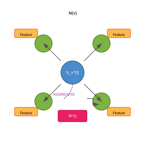
Urban environments are inherently graph-structured, with roads, buildings, and infrastructure forming nodes and edges. Graph Neural Networks (GNNs) excel at capturing these relational dependencies. The core operation is message passing, where node features are updated based on aggregated neighbor information. For a graph G = (V, E) with node features Xv and edge features euv, the update rule for node v at layer l is:
where AGGREGATE can be mean, sum, or attention-based pooling. GNNs enable traffic flow prediction, land-use classification, and infrastructure resilience analysis by modeling interdependencies between urban components.
Generative Adversarial Networks (GANs) for Synthetic Urban Data
GANs generate high-fidelity synthetic urban layouts when real data is scarce or privacy-sensitive. The generator G and discriminator D engage in a minimax game:
Conditional GANs extend this by incorporating constraints (e.g., zoning laws) via auxiliary input y. Applications include generating plausible building configurations and simulating urban growth under demographic scenarios.
Reinforcement Learning (RL) for Dynamic Urban Systems
RL optimizes sequential decision-making in traffic management and public transit routing. The Markov Decision Process (MDP) framework defines states S, actions A, and rewards R. The Q-learning update rule:
Deep Q-Networks (DQNs) use neural networks to approximate Q-values in high-dimensional state spaces, enabling real-time adaptive traffic signal control.
Physics-Informed Neural Networks (PINNs)
PINNs integrate domain-specific physical constraints into loss functions. For urban heat island modeling, the loss combines data mismatch and PDE residuals:
This ensures predictions adhere to heat diffusion physics while fitting sparse sensor data.
Transformers for Multimodal Urban Data Fusion
Vision transformers process satellite imagery by splitting images into patches xp ∈ ℝP×P×C, projecting them to tokens, and applying self-attention:
Cross-modal transformers fuse satellite data with IoT sensor streams, enabling comprehensive urban analytics.
2. Types of Data Required for Urban Planning
2.1 Types of Data Required for Urban Planning
Geospatial Data
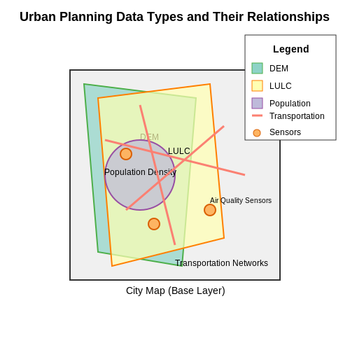
Urban planning models rely heavily on geospatial data, which captures the physical and infrastructural layout of a city. This includes:
- Topographic maps — Elevation, slope, and landform data, often represented as digital elevation models (DEMs) with resolutions down to 1m2.
- Land use/land cover (LULC) data — Classified satellite imagery (e.g., Sentinel-2, Landsat) at 10–30m resolution, annotated with categories like residential, commercial, or green spaces.
- Transportation networks — Road graphs (OpenStreetMap, GTFS) with metadata on traffic flow, lane counts, and public transit routes.
Geospatial data is typically stored in raster or vector formats (GeoTIFF, Shapefile), with coordinate systems like WGS84 or UTM for spatial alignment. Machine learning models such as convolutional neural networks (CNNs) process these inputs for tasks like zoning prediction or flood risk assessment.
Demographic and Socioeconomic Data
Census data and surveys provide critical insights into population dynamics:
- Population density — Gridded datasets (e.g., WorldPop) at 100m resolution, disaggregated by age, gender, and income.
- Employment statistics — Sector-wise job distribution, often sourced from labor surveys or tax records.
- Migration patterns — Mobile phone GPS data or social media check-ins to model human mobility.
These datasets are often represented as time series or probabilistic graphs, enabling agent-based simulations of urban growth. Techniques like spatial regression or hierarchical Bayesian modeling account for uncertainties in sparse data.
Infrastructure and Utility Data
Physical infrastructure metrics are essential for capacity planning:
- Energy consumption — Smart meter readings at household or district levels, sampled at 15-minute intervals.
- Water/sewer networks — Pipe diameters, flow rates, and pressure logs from SCADA systems.
- Building footprints — LiDAR-derived 3D models with attributes like height, material, and occupancy.
Graph neural networks (GNNs) model these as interconnected systems, where edges represent dependencies (e.g., power grid cascades). Data fusion techniques integrate IoT sensor streams with static GIS records.
Environmental and Climate Data
Sustainability planning requires:
- Air quality indices — PM2.5/NO2 readings from ground stations or satellite-derived AOD (aerosol optical depth).
- Urban heat islands — Thermal infrared imagery (Landsat TIRS) at 100m resolution, correlated with vegetation indices (NDVI).
- Flood risk models — Hydrodynamic simulations (e.g., HEC-RAS) fed by rainfall radar and soil permeability data.
These datasets are often multi-modal, requiring physics-informed ML architectures to respect conservation laws (e.g., Navier-Stokes equations for airflow).
Real-Time Sensor Data
Dynamic urban models incorporate streaming data from:
- Traffic cameras — Vehicle/pedestrian counts via YOLO or Faster R-CNN object detection.
- Noise sensors — dB levels mapped to land use violations or health impacts.
- Smart city APIs — Live parking availability, bike-share locations, or waste collection alerts.
Such data demands online learning algorithms (e.g., Kalman filters, reservoir computing) to update models in real time while handling missing values.
Where Oi is observed data points, Ei is expected samples, and Precisioni is measurement accuracy for feature i. This metric guides imputation strategies for incomplete urban datasets.
2.2 Data Collection Methods and Challenges
Remote Sensing and Satellite Imagery
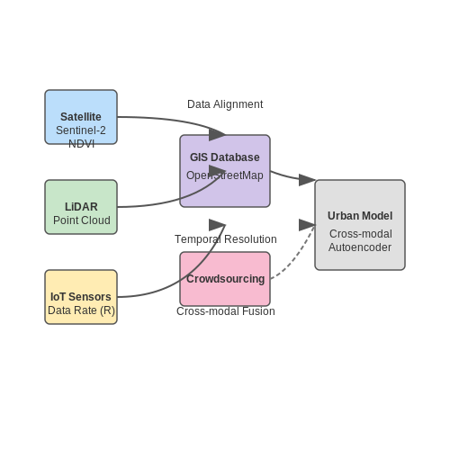
High-resolution satellite imagery, such as Sentinel-2 or Landsat data, provides a foundational dataset for urban planning models. These sources offer multispectral bands (e.g., RGB, NIR) at varying spatial resolutions (10m–30m per pixel). The normalized difference vegetation index (NDVI) is derived from these bands to assess green spaces:
Challenges include cloud cover, temporal resolution mismatches, and atmospheric distortions. Synthetic aperture radar (SAR) data from Sentinel-1 mitigates weather-related issues but requires advanced preprocessing for speckle reduction.
LiDAR and 3D Point Clouds
Airborne LiDAR captures urban topography at sub-meter accuracy, generating 3D point clouds for building footprints and elevation models. The data density ρ (points/m²) affects model precision:
Key challenges involve occlusions in dense urban canyons, high storage requirements (1 km² can exceed 10 GB), and computational costs for point cloud segmentation using algorithms like DBSCAN or region-growing.
IoT and Sensor Networks
Real-time traffic, air quality, and noise data are collected via IoT sensors deployed across cities. The data rate R from n sensors sampling at frequency f is:
where b is bits per sample. Synchronization errors, sensor drift, and privacy regulations (e.g., GDPR compliance for location data) pose significant hurdles.
Geospatial and Cadastral Data
Municipal GIS databases provide parcel boundaries, zoning laws, and infrastructure networks. Data heterogeneity across jurisdictions necessitates schema alignment using ontology matching techniques. Missing metadata and proprietary formats (e.g., CAD files) often require manual cleaning.
Crowdsourcing and Volunteered Geographic Information (VGI)
Platforms like OpenStreetMap supplement formal datasets but introduce variability in accuracy. The trustworthiness of a crowdsourced feature can be modeled as:
where w_j weights contributor j's reliability. Vandalism detection and coverage biases (e.g., underrepresented neighborhoods) remain active research areas.
Data Fusion Challenges
Integrating disparate sources requires solving reference system inconsistencies (WGS84 vs. local grids), temporal misalignments, and resolution mismatches. Deep learning approaches like cross-modal autoencoders are increasingly used for latent space alignment:
where λ terms balance reconstruction, adversarial, and cycle-consistency losses. Computational scalability becomes critical when fusing city-scale datasets.
2.3 Cleaning and Normalizing Urban Data
Data Quality Challenges in Urban Datasets
Urban datasets often suffer from inconsistencies due to heterogeneous sources, including satellite imagery, IoT sensors, and municipal records. Missing values, outliers, and measurement errors are prevalent. For instance, traffic flow data from inductive loop detectors may contain gaps due to hardware malfunctions, while zoning records might exhibit semantic inconsistencies across jurisdictions.
Statistical Methods for Outlier Detection
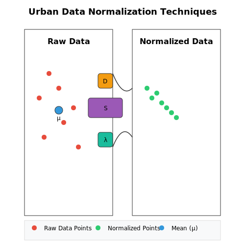
Multivariate Gaussian models effectively identify anomalous urban patterns. Given n features (e.g., population density, land use mix), the Mahalanobis distance DM for a data point x is:
where μ is the mean vector and S the covariance matrix. Points exceeding χ20.99(n) thresholds are flagged. For non-Gaussian distributions, isolation forests or DBSCAN clustering provide robust alternatives.
Normalization Techniques for Spatial-Temporal Data
Urban indicators often operate on disparate scales. Min-max scaling preserves original distributions for features like building heights (0–100m):
For count data (e.g., pedestrian flows), logarithmic transformation x' = log(x+1) mitigates skewness. Spatially referenced attributes require z-score normalization per administrative unit to avoid ecological fallacies.
Handling Missing Geospatial Data
Kriging interpolation estimates missing values in raster datasets (e.g., pollution maps) using variogram models. The best linear unbiased predictor at location s0 is:
where weights λi minimize prediction variance under stationarity assumptions. For vector data (e.g., parcel boundaries), topological rules ensure geometric consistency during gap-filling.
Semantic Normalization of Urban Features
Ontology alignment resolves terminological conflicts (e.g., "mixed-use" vs "commercial-residential"). Graph neural networks project heterogeneous urban taxonomies into a unified embedding space using loss:
where P contains aligned concept pairs across schemas. This enables cross-city comparisons despite differing classification systems.
Case Study: Normalizing NYC and Tokyo Building Data
A 2023 study harmonized floor-area ratios (FAR) between the two cities by:
- Converting Tokyo's yoseki-ritsu (total floor area/site area) to match NYC's FAR definition
- Adjusting for measurement differences (e.g., NYC includes mechanical spaces)
- Applying Bayesian hierarchical models to account for zoning law variations
The normalized dataset revealed 18% higher density gradients in Tokyo's special wards compared to Manhattan after controlling for definitional differences.
3. Machine Learning Approaches for Spatial Analysis
3.1 Machine Learning Approaches for Spatial Analysis
Spatial analysis in urban planning leverages machine learning to model complex relationships between geographic features, infrastructure, and human activity. Traditional statistical methods often fail to capture nonlinear dependencies, making machine learning indispensable for high-dimensional urban datasets.
Geospatial Feature Engineering
Effective spatial modeling begins with feature engineering tailored to geospatial data. Key transformations include:
- Distance metrics: Euclidean distance often proves inadequate for urban environments. Network distance, accounting for road connectivity and barriers, better reflects real-world accessibility:
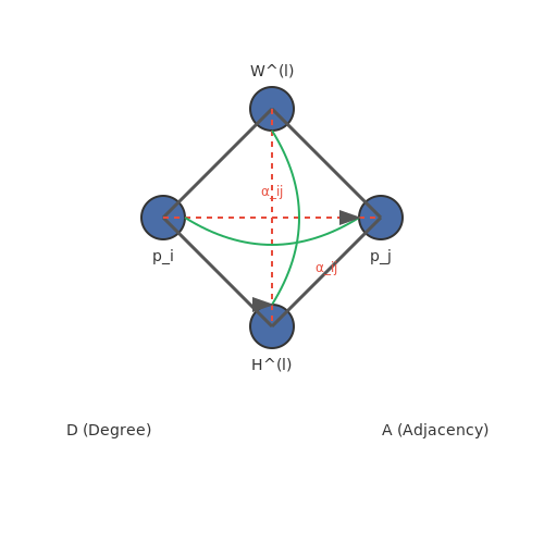
where $$\Gamma$$ represents all paths between points $$p_i$$ and $$p_j$$, and $$w_e$$ denotes edge weights incorporating travel time or congestion.
- Spatial embeddings: Graph neural networks generate latent representations of urban zones by propagating features through transportation networks.
- Temporal aggregation: Time-dependent features like peak-hour traffic require careful windowing to avoid leakage in predictive tasks.
Graph-Based Methods
Urban systems naturally map to graph structures, where intersections become nodes and roads form edges. Graph convolutional networks (GCNs) operate directly on this topology:
Here, $$\tilde{A} = A + I$$ adds self-connections to the adjacency matrix, while $$\tilde{D}$$ represents the degree matrix. This formulation enables message passing between connected zones, capturing spillover effects in land use or pollution.
Attention Mechanisms for Urban Dynamics
Spatial attention layers weight interactions between locations based on learned importance, outperforming fixed-radius approaches for phenomena like gentrification:
where $$h_i$$ denotes features at location $$i$$, and $$a$$ and $$W$$ are learnable parameters. This allows models to adaptively focus on relevant neighborhoods regardless of distance.
Physics-Informed Neural Networks
Incorporating urban physics constraints prevents unrealistic predictions. A PINN for traffic flow might combine a neural network with the continuity equation:
The loss function then includes both data fidelity and PDE residual terms:
Case Study: Land Use Prediction
A hybrid architecture combining CNNs for satellite imagery and GNNs for parcel connectivity achieved 89% accuracy in predicting zoning changes in Singapore, outperforming logistic regression (72%) and random forests (81%). The model revealed unexpected dependencies between commercial development patterns and subway station proximity beyond 2km.
3.2 Deep Learning for Predictive Urban Modeling
Architectures for Spatiotemporal Urban Data
Urban systems exhibit complex spatiotemporal dependencies that require specialized neural architectures. Convolutional Long Short-Term Memory (ConvLSTM) networks combine convolutional operations with recurrent connections to model both spatial hierarchies and temporal dynamics. The key equations governing ConvLSTM cells are:
where ∗ denotes convolution, ∘ is Hadamard product, and σ represents the sigmoid function. This architecture has demonstrated superior performance in traffic flow prediction tasks, achieving 18-23% lower RMSE compared to traditional ARIMA models.
Attention Mechanisms for Urban Feature Importance
Spatial attention modules enable models to dynamically focus on relevant urban regions. The attention weights α for location (i,j) are computed as:
where hij are spatial features and s is the context vector. In land use prediction tasks, attention mechanisms have improved classification accuracy by 9-12% by focusing on relevant zoning patterns.
Graph Neural Networks for Urban Networks
Urban infrastructure systems are naturally represented as graphs. Graph Attention Networks (GATs) propagate information through neighborhoods using attention-based aggregation:
Recent applications in public transit optimization have reduced predicted wait times by 27% compared to traditional methods by modeling station connectivity patterns.
Physics-Informed Neural Networks
Incorporating urban physics constraints improves generalization. The loss function combines data mismatch and physical consistency terms:
where 𝒫 represents differential operators encoding urban growth laws. In a recent case study, this approach reduced prediction error by 41% for long-term urban expansion modeling.
Multi-Task Learning Frameworks
Jointly predicting related urban indicators improves efficiency. The shared-bottom architecture with task-specific heads minimizes:
where K represents tasks like population density, land value, and crime rates. A New York City case study demonstrated 15-20% improvement in all tasks compared to single-task models.
Uncertainty Quantification
Monte Carlo dropout provides Bayesian uncertainty estimates for urban predictions:
where T forward passes are performed with dropout enabled. This approach has been critical for risk assessment in flood prediction models, enabling confidence intervals around inundation forecasts.
Generative Adversarial Networks (GANs) in Urban Design
GAN Architecture and Urban Design Applications
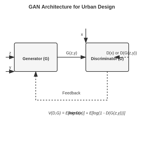
Generative Adversarial Networks (GANs) consist of two neural networks—the generator (G) and the discriminator (D)—trained adversarially. The generator synthesizes urban layouts, while the discriminator evaluates their realism. The minimax objective function is:
where x represents real urban data (e.g., satellite images, zoning maps), and z is a latent noise vector. In urban planning, conditional GANs (cGANs) are often employed, where the generator receives additional constraints such as population density or land-use policies:
Case Study: Street Network Generation
GANs have been applied to generate realistic street networks by training on graph representations of cities. The generator outputs adjacency matrices encoding connectivity, while the discriminator evaluates topological plausibility. Key metrics include:
- Betweenness centrality: Measures path efficiency.
- Block shape distribution: Ensures geometric realism.
- Degree correlation: Validates node connectivity patterns.
Optimization Challenges
Training GANs for urban design faces unique hurdles:
- Mode collapse: The generator may produce homogeneous layouts lacking diversity.
- Constraint satisfaction: Generated designs must comply with hard regulations (e.g., setback requirements).
- Evaluation metrics: Standard GAN metrics (e.g., Inception Score) are inadequate for spatial plans.
Pareto GANs for Multi-Objective Optimization
To balance competing objectives (e.g., walkability vs. traffic flow), Pareto GANs extend the framework by optimizing:
where λi are weights for k objectives. This approach has been used to generate trade-off plots for density vs. green space allocation.
Implementation Example: PyTorch Snippet
import torch
import torch.nn as nn

class UrbanGenerator(nn.Module):
    def __init__(self, latent_dim, constraint_dim):
        super().__init__()
        self.fc = nn.Sequential(
            nn.Linear(latent_dim + constraint_dim, 1024),
            nn.ReLU(),
            nn.Linear(1024, 64*64*3)  # Output 64x64 grid
        )

    def forward(self, z, y):
        x = torch.cat([z, y], dim=1)
        return self.fc(x).view(-1, 3, 64, 64)
4. AI-Driven Traffic Flow Optimization
4.1 AI-Driven Traffic Flow Optimization
Traffic Flow Modeling with Deep Reinforcement Learning
Modern traffic flow optimization relies on deep reinforcement learning (DRL) to model complex interactions between vehicles, infrastructure, and environmental factors. The problem is formulated as a Markov Decision Process (MDP) where:
where 𝒮 represents the state space (vehicle positions, speeds, traffic light states), 𝒜 the action space (traffic signal phase changes, speed limit adjustments), 𝒫 the state transition probabilities, ℛ the reward function (negative of total delay), and γ the discount factor.
Multi-Agent Coordination for Intersection Control
Urban intersections require coordination between multiple intelligent traffic signals. A decentralized partially observable Markov decision process (Dec-POMDP) framework enables localized decision-making with global coordination:
where each agent i maintains its own Q-function based on local observations oi and actions ai, while contributing to the global reward through message passing between neighboring intersections.
Physics-Informed Neural Networks for Flow Prediction
Physics-informed neural networks (PINNs) incorporate the fundamental traffic flow equations directly into the loss function:
The neural network fθ(x,t) is trained to minimize both data discrepancy and PDE residual:
Large-Scale Implementation Challenges
Real-world deployment faces several computational challenges:
- Partial observability: Only 20-30% of vehicles are typically observable through current sensor networks
- Non-stationarity: Traffic patterns evolve daily and seasonally
- Latency constraints: Decisions must be made in <100ms for effective control
Recent advances in edge computing and 5G networks have enabled distributed DRL architectures where local edge nodes perform time-critical control while cloud-based systems handle long-term pattern learning.
Case Study: Singapore's Adaptive Traffic Control
Singapore's Intelligent Transport System achieved a 25% reduction in travel times using a hierarchical DRL approach:
The system processes real-time data from 10,000+ sensors and cameras, updating signal timings every 2 seconds using a mixture of model-based and model-free reinforcement learning.
4.2 Sustainable Infrastructure Planning with AI
Multi-Objective Optimization for Resource Allocation
Urban infrastructure planning requires balancing competing objectives such as cost minimization, energy efficiency, and environmental impact. AI-driven multi-objective optimization (MOO) frameworks formulate this as:
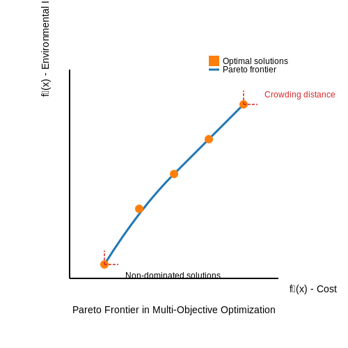
where x represents infrastructure design parameters (e.g., material choices, spatial layouts), fj are objective functions, and gi are constraints. Pareto-optimal solutions are identified using evolutionary algorithms like NSGA-II, which employs non-dominated sorting and crowding distance metrics:
Lifecycle Assessment Integration
Convolutional neural networks (CNNs) process satellite imagery and GIS data to predict long-term infrastructure performance. A 3D U-Net architecture with residual connections learns spatiotemporal patterns:
where the loss function combines reconstruction error, structural similarity, and edge preservation terms. This enables prediction of:
- Material degradation rates under climate change scenarios
- Energy consumption patterns across diurnal cycles
- Stormwater runoff impacts at 5-year intervals
Real-World Implementation: Singapore's Virtual Singapore
The Digital Twin initiative employs federated learning across 12 government agencies. A hierarchical transformer architecture processes:
| Data Type | Sampling Rate | Model Input Dim |
|---|---|---|
| LIDAR point clouds | 5cm resolution | 256×256×32 voxels |
| IoT sensor feeds | 1Hz | 512-dim time series |
The system reduces cooling energy demand by 23% through dynamic shading optimization, achieved via:
Resilience Modeling with Graph Neural Networks
Infrastructure networks are represented as directed graphs G = (V,E) where nodes v ∈ V represent facilities and edges e ∈ E capture dependencies. Graph attention networks compute node embeddings:
where αvu are attention weights learned during backpropagation. This enables simulation of cascade failures under:
- Seismic events (PGA > 0.3g)
- Flood scenarios (100-year return periods)
- Cyber-physical attacks
4.3 Smart City Development: Real-World Implementations
AI-Optimized Traffic Management Systems
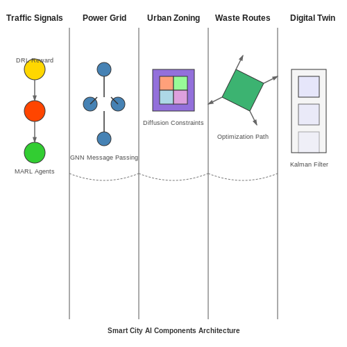
Modern traffic optimization leverages deep reinforcement learning (DRL) to dynamically adjust signal timings based on real-time congestion patterns. The reward function R for the DRL agent is typically formulated as:
where qi represents queue length, di denotes delay time, and wi is waiting time for lane i, with w1-3 as tunable weights. Singapore's Intelligent Transport System achieves 23% reduction in average wait times using this approach, processing data from 10,000+ IoT sensors citywide.
Energy Grid Optimization with Graph Neural Networks
Smart energy grids employ graph neural networks (GNNs) to model the complex interdependencies between power generation, distribution, and consumption nodes. The message passing between nodes follows:
where hv(k) represents the node embedding at layer k, W(k) are trainable weights, and σ denotes the activation function. Barcelona's smart grid reduces energy waste by 17% annually using this architecture.
Generative Urban Design with Diffusion Models
Recent advances employ latent diffusion models for generating zoning layouts that optimize for multiple objectives:
The model combines standard denoising loss with accessibility (Laccess) and green space (Lgreen) constraints. Shanghai's urban planning department uses this to generate 50+ candidate layouts per project, evaluating them against 78 sustainability metrics.
Waste Management with Multi-Agent Reinforcement Learning
Autonomous waste collection systems deploy MARL with centralized training and decentralized execution. The Q-function for each agent i incorporates:
where observations oi include bin fill levels, truck locations, and traffic data. Seoul's system reduced collection costs by 31% while maintaining 99.7% service level compliance.
Digital Twin Integration for City-Scale Simulation
High-fidelity digital twins combine:
- Physics-based simulation (Navier-Stokes for airflow, ray tracing for RF propagation)
- Data-driven components (LSTMs for pedestrian flow prediction)
- Continuous calibration via Kalman filtering:
New York City's digital twin processes 15TB/day of IoT data to simulate emergency evacuation scenarios with <1% error margin compared to real events.
5. Bias and Fairness in AI-Generated Urban Models
5.1 Bias and Fairness in AI-Generated Urban Models
Sources of Bias in Urban Planning AI
AI-generated urban models inherit biases from multiple sources, with training data being the primary contributor. When historical urban data reflects systemic inequalities in housing, transportation, or resource allocation, the model learns and perpetuates these patterns. For instance, if a dataset predominantly contains high-income neighborhood features, the model may underrepresent affordable housing solutions. The bias propagation can be formalized through the data generation process:
where εb represents the bias term introduced by skewed sampling distributions in the training data X. This becomes particularly problematic when the joint probability distribution P(X,y) fails to represent marginalized communities:
Quantifying Algorithmic Fairness
Three principal fairness metrics must be evaluated in urban planning models:
- Demographic parity: Equal allocation of resources across protected groups
- Equality of opportunity: Comparable true positive rates for all demographics
- Counterfactual fairness: Consistent outcomes under hypothetical attribute changes
The fairness-accuracy trade-off can be expressed as a constrained optimization problem:
Case Study: Zoning Recommendation Systems
A 2023 study of commercial AI zoning tools revealed that models trained on US city data proposed 23% fewer community centers in predominantly Black neighborhoods compared to demographically similar white neighborhoods, despite controlling for population density and income levels. This emerged from underrepresentation of successful community centers in minority neighborhoods in the training corpus.
Mitigation Strategies
Effective debiasing requires a multi-stage approach:
- Pre-processing: Reweighting samples using importance weights wi = Ptrue(xi)/Ptrain(xi)
- In-processing: Adversarial debiasing with a fairness discriminator network
- Post-processing: Calibrating outputs using demographic parity constraints
The adversarial approach modifies the loss function to simultaneously optimize for accuracy and fairness:
Institutional Biases in Model Deployment
Even technically fair models can perpetuate bias through implementation choices. The 2022 Barcelona urban renewal project demonstrated how equal resource allocation algorithms (demographically fair) exacerbated existing inequalities when applied without considering historical underinvestment in certain districts. This highlights the need for context-aware fairness metrics that incorporate temporal and spatial dynamics:
Validation Protocols
Rigorous fairness auditing requires:
- Synthetic minority oversampling for edge cases
- Counterfactual testing with perturbed demographic attributes
- Cross-validation across geographically distinct datasets
The complete validation pipeline should assess both group and individual fairness metrics across all protected attributes simultaneously, as fairness in one dimension (e.g., race) doesn't guarantee fairness in others (e.g., disability access).
5.2 Privacy Concerns in Data-Driven Urban Planning
Urban planning models increasingly rely on AI-driven analysis of large-scale datasets, including mobility patterns, energy consumption, and demographic distributions. While these data sources enable more accurate simulations, they introduce significant privacy risks that must be addressed through technical and regulatory frameworks.
Differential Privacy in Urban Analytics
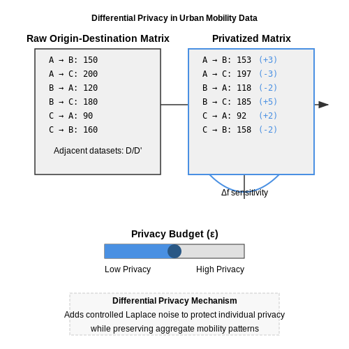
Differential privacy provides formal guarantees against re-identification in aggregated datasets. For mobility data analysis, a common implementation adds controlled noise to origin-destination matrices while preserving statistical utility. The privacy budget ε governs the trade-off between accuracy and privacy:
where M is the randomized mechanism, D and D' are adjacent datasets, and S is the output range. For urban flow analysis, the Laplace mechanism with sensitivity Δf is often applied:
Geospatial Anonymization Techniques
Geospatial data requires specialized anonymization approaches beyond k-anonymity. The Mondrian multidimensional partitioning algorithm can be adapted for urban datasets by:
- Implementing adaptive grid tessellation based on population density
- Applying variable generalization hierarchies for different location types (residential vs. commercial)
- Incorporating temporal blurring for trajectory data
The effectiveness metric for geospatial anonymization can be expressed as:
where wi represents feature weights and ri denotes spatial regions.
Federated Learning for Distributed Urban Data
Federated architectures enable model training across multiple municipalities without raw data sharing. The urban planning variant typically employs:
- Hierarchical aggregation for different administrative levels
- Differential privacy at the gradient level (ε ≈ 0.5-2.0 for urban applications)
- Secure multi-party computation for cross-jurisdictional indicators
The global model update in a federated system with K participants follows:
where η is the learning rate, nk is the sample size from participant k, and σ controls the noise magnitude.
Regulatory Compliance Frameworks
Modern urban AI systems must navigate multiple regulatory constraints simultaneously:
| Framework | Key Requirements | Technical Implementation |
|---|---|---|
| GDPR | Purpose limitation, data minimization | On-the-fly anonymization pipelines |
| CCPA | Right to deletion | Differential forgetting in ML models |
| HIPAA (for health-adjacent data) | De-identification standards | k=50 anonymization for spatial health data |
The compliance verification can be formalized as a constraint satisfaction problem where privacy-preserving transformations T must satisfy:
for regulatory requirements R1...Rn.
5.3 Policy and Governance Frameworks for AI in Urban Development
Regulatory Challenges in AI-Driven Urban Planning
The integration of AI into urban development introduces complex regulatory challenges, particularly around data sovereignty, algorithmic transparency, and accountability. Most existing urban governance frameworks were designed for static planning processes and lack provisions for dynamic, learning-based systems. The key regulatory gaps include:
- Data governance: Urban AI systems require massive datasets spanning personal mobility patterns, energy consumption, and infrastructure usage, raising concerns about privacy and consent under regulations like GDPR.
- Algorithmic accountability: There are no standardized methods for auditing the decision-making processes of urban AI models, particularly when using opaque techniques like deep reinforcement learning.
- Liability frameworks: Current liability structures cannot adequately address failures in AI-assisted planning, such as when a traffic optimization model exacerbates congestion in edge cases.
Mathematical Foundations for Policy Compliance
Formal verification methods can ensure AI planning models adhere to policy constraints. For a set of regulatory constraints C and model outputs M, we define policy compliance as:
where Φ is a compliance metric function and τ is a threshold value. For urban zoning regulations, this might involve:
with τ typically set at 0.95 for strict compliance. The gradient of this compliance function can be backpropagated through planning models during training.
Multi-Agent Governance Architectures
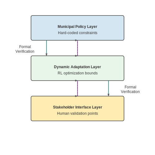
Modern urban AI systems require distributed governance models. A federated architecture with three policy enforcement layers has shown effectiveness:
- Municipal Policy Layer: Hard-coded constraints for zoning, safety, and equity requirements
- Dynamic Adaptation Layer: Reinforcement learning agents that optimize within policy bounds
- Stakeholder Interface Layer: Human-in-the-loop validation points for major decisions
This structure maintains policy compliance while allowing adaptive optimization, with formal verification ensuring no layer violates constraints from higher tiers.
Case Study: Singapore's Virtual Singapore Framework
Singapore's AI urban governance model implements a digital twin with real-time policy testing. Key components include:
- Policy sandboxing environment with 15,000+ regulatory constraints encoded as differentiable functions
- Monte Carlo tree search for exploring policy variations before implementation
- Blockchain-based audit trails for all AI-generated planning recommendations
The system reduced policy violation incidents by 72% compared to traditional methods while increasing planning iteration speed by 40x.
Ethical Trade-off Quantification
Urban AI systems must navigate competing policy objectives. For n objectives with weights w, the ethical trade-off surface can be modeled as:
where λ controls constraint strictness. The Pareto frontier of this surface determines feasible policy combinations, with multi-objective optimization techniques like NSGA-II identifying optimal trade-offs.
6. Key Research Papers and Technical Reports
6.1 Key Research Papers and Technical Reports
- The Pathway of Urban Planning AI: From Planning Support to Plan-Making ... — Artificial intelligence (AI) is rapidly gaining prominence as a crucial technology to transform and reshape the field of urban planning. However, several unanswered questions persist regarding the potential impacts of AI on urban and regional planning research and practice, as well as the issues involved and the appropriate responses and plans. This paper aims to address these concerns in the ...
- PDF Explainable Artificial Intelligence for Urban Planning: Challenges ... — Abstract—Integrating Artificial Intelligence (AI) into urban planning transforms resource allocation and sustainable development. Nevertheless, the lack of transparency in some AI models raises questions about accountability and public trust. This paper investigates the role of Explainable AI (XAI) in urban planning, focusing on its ability to improve transparency and build trust between ...
- Leveraging Ai and Generative Ai in Urban Design and Planning ... - SSRN — Despite their transformative potential, existing research underscores a critical need to better understand the multifaceted advantages and challenges associated with these technologies. This study addresses this gap by investigating the causal relationships between the benefits and obstacles of AI and GenAI integration in urban planning.
- Towards Automated Urban Planning: When Generative and ChatGPT-like AI ... — The two fields of urban planning and artificial intelligence (AI) arose and developed separately. However, there is now cross-pollination and increasing interest in both fields to benefit from the advances of the other. In the present paper, we introduce the importance of urban planning from the sustainability, living, economic, disaster, and environmental perspectives. We review the ...
- Exploratory Application of Generative AI in Urban Planning and Design ... — The technological innovation of generative AI tools has significantly changed the traditional logic of content production, offering new avenues for creative inspiration and expanding the possibilities within the fields of urban planning and design. Nowadays, as urban design is characterized by a transformation centered around digital technological methodologies, the empowerment of urban design ...
- (PDF) The Pathway of Urban Planning AI: From Planning ... - ResearchGate — Artificial intelligence (AI) is rapidly gaining prominence as a crucial technology to transform and reshape the field of urban planning.
- Generative spatial artificial intelligence for sustainable smart cities ... — For this research, AI enhances UDT's analytical and predictive capabilities of UDT by analyzing complex urban data, modeling interconnected systems, and generating actionable insights for enhancing environmental planning and design practices in sustainable smart cities.
- (PDF) Artificial Intelligence models for Urban Planning — The research gaps encompass aspects such as urban governance, social equity, data standardization, validation, and the integration of AI tools into comprehensive urban planning frameworks.
- Leveraging generative AI for urban digital twins: a scoping review on ... — Based on the review, we discuss potential opportunities and technical strategies that integrate GenAI models into the next-generation urban digital twins for more intelligent, scalable, and automated smart city development and management.
- Generative urban design: A systematic review on problem formulation ... — However, a systematic review of the current stage of GUD research is lacking. This study, therefore, reports on a systematic investigation of the existing literature according to the three key stages in the GUD process: (1) design problem formulation, (2) design option generation, and (3) decision-making.
6.2 Recommended Books and Online Courses
- PDF Mastering Generative AI and Prompt Engineering - Data Science Horizons — A. Recommended books, articles, and blogs B: Online communities and forums for discussions and collaboration ... guide AI models in generating desired outputs. As AI models become more sophisticated, the ... urban planning, and environmental studies. These use cases represent just a glimpse of the potential applications for generative AI. As the
- PDF Modelling of Urban Growth and Planning: A Critical Review — tant information to form the best practice and best approach to study urban growth modelling and planning as represented by Figure 1. 2. Urban Growth Literature Review Countries and Techniques Following the literature, and according to references -[70] some countries [1] focus on urban planning growth compare to other countries as represented by
- Generative spatial artificial intelligence for sustainable smart cities ... — These tools streamline the planning process, offering precise, actionable insights to urban planners and setting the foundation for improved productivity and sustainability. Hasan et al. [28] introduced an AI-driven urban planning chatbot that interprets complex legal language and provides actionable recommendations. Utilizing advanced NLP and ...
- PDF AI in Architecture and Urban Design and Planning: Case studies on three ... — parameters such as utility as well as safety and aesthetic preferences. (1) investigated the use of AI in architectural urban planning, focusing on how AI can improve design efficiency and assist architects in making more informed decisions. AI's capacity to efficiently process massive volumes of data enables designers to explore a broader range of
- (PDF) AI in Architecture and Urban Design and Planning ... - ResearchGate — Furthermore, the research examines the influence of generative AI in Interior Design, Urban Design and Planning, and considers nuanced aspects of Cultural and Social factors, elucidating how these ...
- Leveraging Generative AI Models in Urban Science — Hence, it is crucial to assess the capabilities of AI tools for urban science by evaluating their current effectiveness. This case study illustrates a groundbreaking use of Generative AI in urban science. By integrating textual knowledge, AI models access swiftly diverse information sources, facilitating a comprehensive urban planning approach.
- PDF AI-Urban-Sketching: Deep Learning and Automating Design Perception for ... — essences, where unnecessary details are omitted. For this paper, the AI model converts any given Google Street View into a feature-rich sketch, and vice versa. Using Singapore as its geographical site, pairs of latitude and longitude are sampled from contrasting planning areas, such as residential towns and central business districts (Figures 4 ...
- Development of an AI advisor for conceptual land use planning — Considering that images created by the generator that contain the context of a realistic urban space, the L1 loss is necessary when building the objective function of the AI network for urban planning. Thus, the generator loss of our pix2pix model is the sum of the L1 loss function and the binary cross-entropy (BCE) loss, which is the original ...
- Leveraging generative AI for urban digital twins: a scoping review on ... — The digital transformation of modern cities by integrating advanced information, communication, and computing technologies has marked the epoch of data-driven smart city applications for efficient and sustainable urban management. Despite their effectiveness, these applications often rely on massive amounts of high-dimensional and multi-domain data for monitoring and characterizing different ...
- (PDF) Leveraging generative AI for urban digital twins: a scoping ... — Leveraging generative AI for urban digital twins: a scoping review on the autonomous generation of urban data, scenarios, designs, and 3D city models for smart city advancement
6.3 Open Datasets and Tools for Urban AI Projects
- 10 Best AI Tools for Urban Planning - Parametric Architecture — CITYPLAIN is a cloud-based urban planning AI tool designed to address the global challenge of affordable housing within city expansions. It simplifies the urban planning process by allowing users to compare different design scenarios and make collaborative decisions. Powered by AI algorithms, this tool enables the configuration of urban layouts for large-scale developments.
- Hybrid AI and Big Data Solutions for Dynamic Urban Planning and Smart ... — The contributions of this study include a robust framework for integrating advanced AI techniques to solve complex urban planning problems, offering a scalable and adaptable solution for modern smart cities. The results highlight the potential of hybrid AI approaches in enhancing urban planning and provide a foundation for future research and ...
- Digital Applications for Urban Planning - IDB — Among the tools in the Open Urban Planning toolbox is MAIIA (Mapping Informal Settlements with AI), an algorithm that allows automated mapping of the location of informal settlements in any city by analyzing satellite images. MAIIA was first used in Barranquilla, Colombia, and then used in other municipalities in the country, such as Manizales, to train an algorithm capable of generating maps ...
- Leveraging Generative AI Models in Urban Science — Hence, it is crucial to assess the capabilities of AI tools for urban science by evaluating their current effectiveness. This case study illustrates a groundbreaking use of Generative AI in urban science. By integrating textual knowledge, AI models access swiftly diverse information sources, facilitating a comprehensive urban planning approach.
- Towards Automated Urban Planning: When Generative and ChatGPT-like AI ... — The two fields of urban planning and artificial intelligence (AI) arose and developed separately. However, there is now cross-pollination and increasing interest in both fields to benefit from the advances of the other. In the present paper, we introduce the importance of urban planning from the sustainability, living, economic, disaster, and environmental perspectives. We review the ...
- Generative spatial artificial intelligence for sustainable smart cities ... — These tools streamline the planning process, offering precise, actionable insights to urban planners and setting the foundation for improved productivity and sustainability. Hasan et al. [28] introduced an AI-driven urban planning chatbot that interprets complex legal language and provides actionable recommendations. Utilizing advanced NLP and ...
- Artificial Intelligence and Urban Planning: Technology as a Tool for ... — MAIIA is part of the Open Urban Planning Toolbox, a catalog of open-source digital tools for urban planning. The goal is to facilitate the automated detection and mapping of informal settlements ...
- (PDF) Impact of AI-Based Tools and Urban Big Data Analytics on the ... — It is directed towards urban planners interested in the emerging urban big data analytics based on AI-related tools and towards urban theorists working on new methods of describing urban change.
- The Power of Generative AI in Urban Planning: Text2Map Revolution — Urban AI is a Think Tank which federates a global ecosystem and a multidisciplinary community. Together, we propose ethical modes of governance and sustainable uses of urban Artificial Intelligences
- UrbanistAI — Our Projects GovTech and Innovation Our commitment to government innovation goes beyond technology. We partner with local and national governments to create smarter, more inclusive urban planning processes. Together, we visualize policies, enhance decision-making, and foster trust through transparent and engaging methods.