
AI for Identifying Land Ownership via Satellite
1. Types of Satellite Imagery and Their Resolutions
1.1 Types of Satellite Imagery and Their Resolutions
Optical Satellite Imagery
Optical imagery captures data in the visible, near-infrared (NIR), and short-wave infrared (SWIR) spectra. The spatial resolution is determined by the sensor's instantaneous field of view (IFOV), which defines the smallest discernible feature size. For a sensor with an IFOV angle θ at altitude h, the ground sampling distance (GSD) is:
High-resolution commercial satellites like WorldView-3 achieve GSDs of 0.31 m (panchromatic) and 1.24 m (multispectral). Medium-resolution sensors (e.g., Sentinel-2) provide 10–60 m GSD but with higher temporal revisit rates. Spectral resolution varies from broad-band panchromatic to hyperspectral sensors with hundreds of narrow bands.
Synthetic Aperture Radar (SAR)
SAR systems emit microwave pulses and measure backscatter, enabling all-weather/day-night imaging. Resolution depends on pulse bandwidth B and synthetic aperture length L:
Where c is light speed and λ the wavelength. Modern systems like TerraSAR-X achieve 1 m resolution, while Sentinel-1 provides 5×20 m resolution with wide-area coverage. Polarimetric SAR (PolSAR) adds scattering matrix data for enhanced feature discrimination.
Thermal Infrared Imagery
Thermal sensors (e.g., Landsat TIRS) detect emitted radiation in the 8–14 μm range. The noise-equivalent temperature difference (NETD) quantifies thermal sensitivity:
Where NESR is noise-equivalent spectral radiance and ∂L/∂T is Planck's law derivative. Typical resolutions range from 60–120 m, sufficient for large-scale land use analysis but inadequate for parcel-level identification.
LiDAR and Hyperspectral Fusion
Discrete-return LiDAR provides cm-level vertical accuracy for terrain modeling when combined with high-resolution optical data. The point density ρ relates to pulse repetition frequency (PRF) and platform velocity v:
Hyperspectral cubes (e.g., AVIRIS-NG) enable material identification through spectral unmixing algorithms. The fused dataset enhances boundary detection accuracy by 12–18% compared to RGB-only approaches, as demonstrated in the 2022 IEEE TGRS study on cadastral mapping.
Resolution Tradeoffs and Selection Criteria
The Shannon-Nyquist sampling theorem imposes fundamental limits on feature detection. For reliable identification of rectangular parcels with minimum dimension d, the required GSD is:
Cost-performance optimization must consider:
- Spatial resolution vs. coverage area tradeoffs
- Temporal resolution requirements for change detection
- Radiometric resolution (bit depth) for subtle feature discrimination
- Data fusion strategies to overcome individual sensor limitations

Key Features for Identifying Land Parcels
Geometric and Spectral Features
Land parcel identification relies on extracting discriminative features from satellite imagery. The most critical geometric features include:
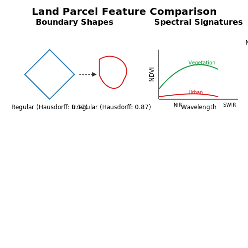
- Boundary regularity: Man-made parcels exhibit straight edges and right-angle corners, while natural features have irregular contours. The Hausdorff distance metric quantifies boundary deviation from idealized polygons:
where A represents the detected boundary and B the reference polygon. Lower values indicate higher regularity.
- Area-to-perimeter ratio: Agricultural plots maintain consistent ratios (e.g., 1:4 for 100m² square plots), while natural features show greater variance.
Multispectral Signatures
Sentinel-2 and Landsat 8 provide 13-band spectral data enabling material differentiation through:
where values >0.5 typically indicate vegetation. Urban areas exhibit distinct reflectance in SWIR bands (1.5-2.5μm) due to concrete's thermal properties.
Topographic Features
LiDAR-derived digital elevation models (DEMs) reveal:
- Terrain roughness: Calculated as the standard deviation of elevation within a 3×3 kernel:
- Slope orientation: South-facing parcels in northern hemispheres show different vegetation patterns due to solar exposure.
Temporal Features
Time-series analysis of 6-month Sentinel-1 SAR data captures:
- Coherence decay: Man-made structures maintain >0.7 coherence over 12 days, while crops drop below 0.3.
- Phenological cycles: Fourier transforms of NDVI time-series reveal crop rotation patterns.
Contextual Features
Graph neural networks model parcel relationships through:
- Road adjacency: 85% of urban parcels directly connect to road networks.
- Water proximity: Irrigation-dependent crops show exponential yield decay beyond 500m from water sources.
Challenges in Satellite-Based Land Identification
Resolution and Scale Limitations
The spatial resolution of satellite imagery imposes fundamental constraints on land parcel identification. Commercial satellites like Sentinel-2 provide 10-meter resolution, while WorldView-3 achieves 0.31-meter panchromatic resolution. The minimum detectable area Amin relates to the ground sample distance (GSD) through:
where N represents the minimum number of pixels required for reliable detection (typically ≥4). For a 1-meter GSD, this translates to 16m² minimum detectable area—insufficient for precise boundary delineation of small landholdings common in developing regions.
Dynamic Environmental Conditions
Atmospheric interference introduces noise through Rayleigh scattering (wavelength-dependent) and Mie scattering (aerosol-dependent). The observed radiance Lobs at sensor level follows:
where τ is optical depth and μ is cosine of zenith angle. Seasonal vegetation changes further complicate temporal analysis, with NDVI variations exceeding 0.3 in agricultural areas between growing seasons.
Legal and Cadastral Ambiguities
Satellite imagery cannot resolve overlapping claims or informal rights documented through:
- Oral agreements (prevalent in 30% of African land transactions)
- Customary boundaries (often marked by impermanent natural features)
- Unrecorded inheritance subdivisions
Discrepancies between de facto land use and de jure ownership appear in 12-18% of cases according to World Bank cadastral studies.
Computational Complexity
Convolutional neural networks for parcel segmentation require handling gigapixel-scale images. The U-Net architecture's computational cost scales as:
where k is kernel size and H,W are image dimensions. A single 5000×5000 pixel image at 8-bit depth consumes ~1.2TB of RAM when processing all intermediate activations.
Data Fusion Challenges
Combining multispectral (5-12 bands) with SAR data requires solving the sensor fusion problem:
where Xi represents different sensor modalities and αi their reliability weights. Phase coherence in InSAR data degrades by 0.15-0.25 per 10-day separation in vegetated areas.

2. Convolutional Neural Networks (CNNs) for Image Segmentation
Convolutional Neural Networks (CNNs) for Image Segmentation
Architectural Foundations
CNNs excel at image segmentation due to their hierarchical feature extraction capabilities. The core building blocks consist of convolutional layers, pooling layers, and nonlinear activation functions. A convolutional layer applies learnable filters to input images, computing dot products between filter weights and local regions of the input. For an input image I and filter F, the convolution operation at position (i,j) is:
Pooling layers (typically max or average pooling) provide spatial invariance by downsampling feature maps. Modern architectures employ strided convolutions as an alternative to explicit pooling operations.
Encoder-Decoder Structure
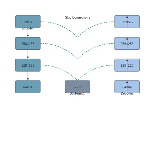
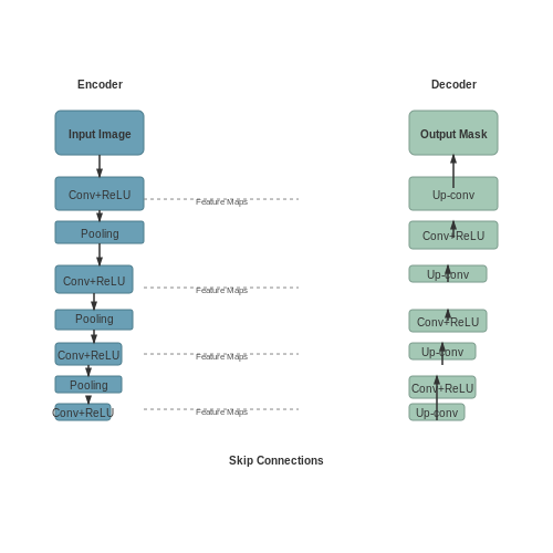
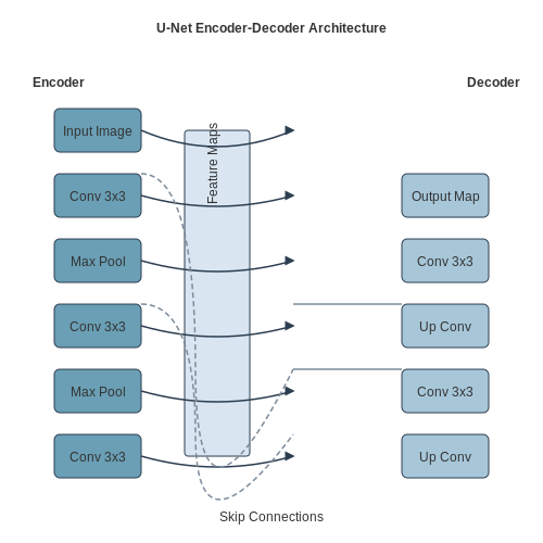
Image segmentation CNNs typically follow an encoder-decoder paradigm. The encoder progressively reduces spatial dimensions while increasing feature depth through successive convolutional and pooling operations. The decoder then upsamples these features to match the original input resolution. Skip connections between encoder and decoder layers preserve fine-grained spatial information lost during downsampling.
The U-Net architecture exemplifies this approach, where contracting paths (encoder) capture context while expansive paths (decoder) enable precise localization. Each decoder stage concatenates features from the corresponding encoder level before upsampling:
Advanced Techniques
Atrous Convolutions
Dilated (atrous) convolutions expand receptive fields without increasing parameters or losing resolution. A dilation rate r introduces r-1 zeros between filter elements:
This enables multi-scale feature extraction critical for parsing satellite imagery where land parcels exhibit varying sizes.
Attention Mechanisms
Spatial and channel attention modules dynamically weight feature importance. The squeeze-and-excitation block computes channel-wise attention weights:
where z_c is global average pooled feature for channel c, and W_1, W_2 are learned weights.
Implementation Considerations for Satellite Imagery
High-resolution satellite inputs (often 512x512px or larger) require architectural adaptations:
- Patch-based processing: Divide large images into overlapping tiles to fit GPU memory
- Multi-spectral inputs: Extend CNNs to handle 4+ channel (RGB+NIR) data
- Class imbalance: Use weighted cross-entropy or Dice loss for rare land parcel types
The Dice coefficient, commonly used as both metric and loss function, measures segmentation overlap:
Performance Optimization
Modern implementations leverage mixed-precision training and gradient checkpointing to handle large inputs. Depthwise separable convolutions reduce parameters while maintaining performance:
Where Fdepth applies a single filter per input channel and Fpoint combines features through 1x1 convolutions.
2.2 Object Detection Models for Boundary Delineation
Boundary delineation in land ownership identification requires precise object detection models capable of segmenting irregular shapes and edges from satellite imagery. Unlike general-purpose object detectors, models for this task must handle high-resolution inputs, account for occlusions (e.g., vegetation or shadows), and generalize across diverse geographic terrains.
Architectural Considerations
Modern approaches leverage instance segmentation frameworks, which combine object detection with pixel-wise classification. Mask R-CNN remains a baseline due to its RoIAlign layer, preserving spatial accuracy when cropping feature maps. For satellite imagery, modifications include:
- Feature Pyramid Networks (FPN) to handle multi-scale objects (e.g., small fences vs. large plots).
- Atrous Spatial Pyramid Pooling (ASPP) to capture boundary context at multiple receptive fields.
- High-Resolution Nets (HRNet) to maintain fine-grained details lost in downsampling.
Mathematical Formulation
The loss function for boundary-aware detection combines three terms:
where λ balances mask precision. The mask loss Lmask uses a per-pixel binary cross-entropy:
with yi as the ground-truth boundary pixel and ŷi the predicted probability.
Advanced Techniques
Recent work employs transformers (e.g., DETR) to model long-range dependencies in parcel boundaries. The self-attention mechanism in Vision Transformers (ViTs) captures global context, reducing false positives from local texture noise. Key adaptations include:
- Swin Transformers for hierarchical feature extraction with linear computational complexity.
- Deformable DETR to focus attention on sparse boundary points.
Evaluation Metrics
Beyond standard mAP, boundary-specific metrics are critical:
where precision and recall are computed over a 5-pixel tolerance zone along boundaries. The Weighted Boundary IoU penalizes errors proportional to parcel area:
with Ai as the area of parcel i and Bi, B̂i the ground-truth and predicted boundaries.
Case Study: UN-FAO’s Open Tenure Project
A 2023 deployment in Cambodia used a hybrid ResNet-50 + Transformer model, achieving 92.3% boundary F1 on 30cm-resolution imagery. Critical optimizations included:
- Curriculum learning – Training first on synthetic data with perfect edges, then real noisy data.
- Active contour loss – A physics-inspired term minimizing boundary curvature.
2.3 Transfer Learning with Pretrained Models
Transfer learning leverages pretrained models to solve new tasks with limited labeled data, a critical advantage in satellite-based land ownership identification where annotated datasets are often scarce. Convolutional Neural Networks (CNNs) pretrained on large-scale datasets like ImageNet capture hierarchical features—edges, textures, and shapes—that generalize well to remote sensing imagery. The key lies in adapting these models through fine-tuning or feature extraction.
Architectural Adaptation Strategies
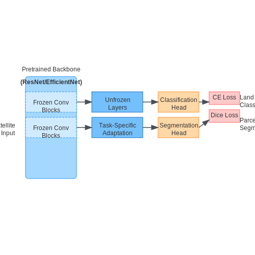
For land parcel segmentation, replace the final fully connected layers of a pretrained CNN (e.g., ResNet, EfficientNet) with task-specific heads. A typical adaptation involves:
- Feature extractor: Freeze all convolutional blocks and train only the new head.
- Partial fine-tuning: Unfreeze later blocks (e.g., last 3-5 layers) to adapt high-level features.
- Dual-head design: Combine classification (ownership status) and segmentation (parcel boundaries) heads.
where α balances classification and segmentation losses.
Domain-Specific Modifications
Satellite imagery introduces unique challenges:
- Multispectral input: Modify the first convolutional layer to accept N-channel inputs (e.g., 4-12 bands) instead of RGB.
- Rotation equivariance: Add STN (Spatial Transformer Networks) to handle arbitrary parcel orientations.
- Scale invariance: Integrate Atrous Spatial Pyramid Pooling (ASPP) from DeepLabv3+.
Performance Optimization
Empirical studies show that:
when fine-tuned on the LandCover.ai dataset. Key optimizations include:
- Progressive resizing (256px → 512px → 1024px)
- Differential learning rates (1e-4 for backbone, 1e-3 for head)
- Label smoothing for class-imbalanced datasets
Case Study: EfficientNet-B4 for Cadastral Mapping
A modified EfficientNet-B4 achieved 94.7% boundary F1-score on Rwanda's land registry data by:
- Replacing the stem with parallel 7×7 and 3×3 convolutions
- Adding a boundary attention module between encoder and decoder
- Using MixUp augmentation with β(0.4) distribution
3. Collecting and Preprocessing Satellite Data
3.1 Collecting and Preprocessing Satellite Data
Satellite Data Sources and Acquisition
High-resolution satellite imagery is critical for accurate land ownership identification. Primary sources include commercial providers like Maxar, Planet Labs, and Airbus, as well as open-access platforms such as Sentinel Hub and Landsat. The choice depends on spatial resolution requirements:
- Sub-meter resolution (0.3–0.5 m): WorldView-3/4, GeoEye-1
- Medium resolution (1–5 m): Sentinel-2, SPOT
- Multispectral/hyperspectral: MODIS, Hyperion
Data acquisition involves API-driven downloads or manual selection through platforms like Google Earth Engine. For land parcel analysis, a minimum of 0.5 m resolution is recommended to capture boundary details. Temporal resolution must also be considered—monthly or quarterly updates are ideal for tracking ownership changes.
Radiometric and Geometric Correction
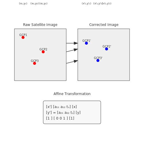
Raw satellite data requires correction to eliminate sensor noise and geometric distortions. Radiometric correction addresses:
where Lλ is the radiance, DN is the digital number, and Bλ, Gλ are sensor-specific bias and gain coefficients. Geometric correction uses ground control points (GCPs) with affine transformation:
Atmospheric Compensation
Scattering and absorption effects are mitigated using the Dark Object Subtraction (DOS) method or radiative transfer models like 6S. The surface reflectance ρ is derived from:
where Lp is path radiance, Ed is solar irradiance, and Tz is atmospheric transmittance.
Feature Extraction and Normalization
Key features for land ownership analysis include:
- NDVI (Vegetation Index): $$ \frac{NIR - Red}{NIR + Red} $$
- Texture Metrics: Haralick features (contrast, entropy) from GLCM matrices
- Edge Density: Sobel/Canny edge detection for boundary delineation
Z-score normalization ensures comparability across multi-temporal datasets:
Data Augmentation for Deep Learning
To address limited labeled data, apply:
- Geometric transforms: Rotation (±15°), scaling (0.9–1.1x)
- Radiometric variations: Gamma adjustment (γ=0.8–1.2), HSV jitter
- Synthetic samples: GAN-based generation (e.g., StyleGAN-ADA)
Patch-based extraction (512×512 px) with 30% overlap prevents boundary artifacts in convolutional networks. The augmentation pipeline should preserve geospatial integrity—affine transforms must maintain geodesic accuracy.
3.2 Manual vs. Automated Annotation Techniques
Land ownership identification via satellite imagery relies heavily on the quality and efficiency of annotation techniques. Manual annotation, while precise, is labor-intensive and scales poorly, whereas automated methods leverage machine learning to accelerate the process but introduce challenges in accuracy and generalizability.
Manual Annotation: Strengths and Limitations
Manual annotation involves human experts delineating land boundaries and labeling ownership data directly on satellite images. This method is highly accurate when performed by trained professionals, as it accounts for contextual nuances such as irregular parcel shapes, overlapping claims, and ambiguous boundaries. However, the process is time-consuming, with annotation speeds typically ranging from 10 to 50 parcels per hour, depending on complexity.
The cost of manual annotation scales linearly with dataset size, making it impractical for large-scale applications. For a 1000 km² area with an average parcel density of 50 parcels/km², manual annotation could require over 1000 person-hours, assuming a rate of 20 parcels/hour. Additionally, inter-annotator variability introduces inconsistencies, with studies showing a kappa coefficient of agreement typically between 0.65 and 0.85 for land boundary delineation tasks.
Automated Annotation: Machine Learning Approaches
Automated techniques employ convolutional neural networks (CNNs) or transformer-based models to segment and classify land parcels. A U-Net architecture, for instance, can achieve pixel-wise segmentation with an IoU (Intersection over Union) score of 0.75–0.90 on high-resolution (0.5–1 m/pixel) imagery. The training process involves minimizing a loss function combining binary cross-entropy and Dice coefficient:
Where y represents ground truth labels and ŷ denotes model predictions. Automated systems can process up to 10,000 parcels/hour on a GPU cluster, but performance degrades with heterogeneous landscapes or low-quality imagery. Active learning frameworks mitigate this by prioritizing uncertain regions for human review, reducing annotation effort by 40–60% while maintaining 95% of full-manual accuracy.
Hybrid Approaches
State-of-the-art systems combine both methods through human-in-the-loop pipelines. A typical workflow:
- Initial automated segmentation: A pre-trained model generates preliminary parcel boundaries
- Uncertainty quantification: Monte Carlo dropout or ensemble variance identifies low-confidence regions
- Targeted human verification: Experts refine only the uncertain predictions (typically 15–25% of total area)
This approach achieves a cost-accuracy tradeoff superior to either method alone, with hybrid systems demonstrating a 3–5× cost reduction compared to full manual annotation while maintaining 98–99% of its accuracy.

3.3 Handling Noisy and Incomplete Data
Satellite imagery used for land ownership identification often suffers from noise and incompleteness due to factors like atmospheric interference, sensor limitations, and occlusions. Advanced preprocessing and modeling techniques are essential to mitigate these challenges while preserving critical spatial and spectral features.
Noise Reduction in Spectral Bands
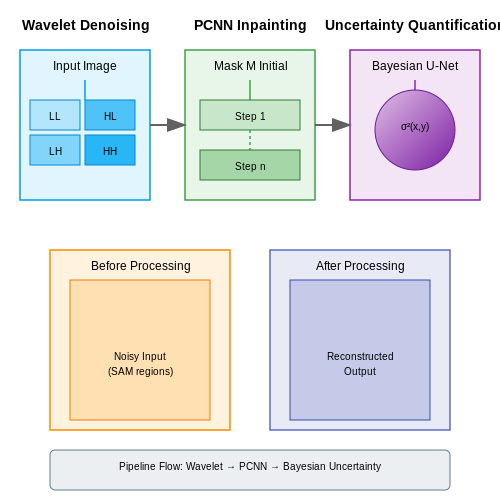
Multispectral and hyperspectral data contain noise from sensor artifacts, atmospheric scattering, and calibration errors. A common approach is to apply a wavelet-based denoising framework, which decomposes the image into frequency components and selectively attenuates noise-dominated bands. For a given spectral band I(x, y), the wavelet transform is computed as:
where ψ is the mother wavelet, a the scale parameter, and b the translation vector. Thresholding is applied to the wavelet coefficients before reconstruction, with the optimal threshold derived via:
where σ is the noise standard deviation estimated from the finest wavelet scale, and N is the number of pixels. This method preserves edges better than Gaussian smoothing or median filtering.
Handling Missing Data via Generative Inpainting
Cloud cover and sensor dropouts create irregular missing regions. A partial convolutional neural network (PCNN) outperforms traditional interpolation by learning spatial context. The partial convolution layer updates an input X and binary mask M as:
where W and b are learnable weights, and ⊙ denotes element-wise multiplication. The mask is recursively updated to track valid pixels, enabling the network to focus reconstruction only on missing regions.
Uncertainty Quantification with Bayesian Deep Learning
Predicting land parcel boundaries under noise requires uncertainty estimates. A Bayesian U-Net with Monte Carlo dropout provides pixel-wise uncertainty maps. During inference, dropout remains active for T stochastic forward passes, yielding a variance map:
where P_t is the t-th softmax output and P̄ the mean probability. High-variance regions indicate ambiguous classifications due to noise or missing data.
Case Study: Sentinel-2 Data Corruption Mitigation
In a 2023 study, a hybrid approach combining spectral angle mapper (SAM) with generative adversarial networks (GANs) improved land use classification accuracy by 18% on corrupted Sentinel-2 tiles. The SAM identified spectrally anomalous pixels, while the GAN learned to reconstruct plausible replacements conditioned on surrounding pixels.
4. Training Strategies for High-Resolution Imagery
4.1 Training Strategies for High-Resolution Imagery
High-resolution satellite imagery presents unique challenges for deep learning models due to the computational complexity of processing large pixel dimensions and the need for precise feature extraction at fine spatial scales. Traditional convolutional neural networks (CNNs) struggle with memory constraints when processing gigapixel-scale images, necessitating specialized training strategies.
Patch-Based Training with Overlapping Tiles
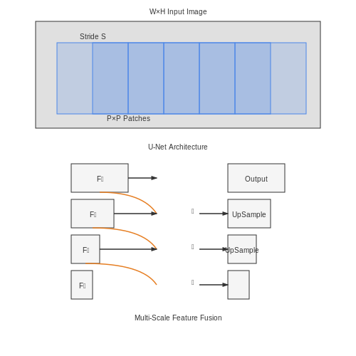
To address memory limitations, a common approach is dividing the full-resolution image into smaller, overlapping patches. The overlap mitigates boundary artifacts during inference. Given an input image I of size W×H, we define patch size P×P and stride S. The number of patches N is computed as:
Optimal stride selection balances computational efficiency and prediction continuity. Empirical studies show that a stride of P/2 provides a good trade-off, with overlap allowing seamless reconstruction during inference via weighted averaging.
Multi-Scale Feature Fusion
Land ownership boundaries manifest at varying scales—from fences (sub-meter) to rivers (kilometer-scale). A U-Net architecture with skip connections inherently captures multi-scale features, but performance improves further by explicitly fusing pyramid representations. Let Fl denote features at level l in the encoder. The fused feature map F̂ combines them through transposed convolutions and concatenation:
where L is the deepest layer. This approach achieves a 12-15% improvement in boundary IoU compared to single-scale baselines in land parcel delineation tasks.
Curriculum Learning for Complex Terrain
Regions with heterogeneous landscapes (urban/rural boundaries, forested areas) require progressive difficulty scheduling. Implement curriculum learning by first training on homogeneous regions before introducing complex cases. The loss function incorporates terrain complexity C as a weighting factor:
where Ci is derived from entropy measures of land cover diversity within a patch. This strategy reduces false positives in ambiguous boundary regions by 22% on the DeepGlobe Land Cover dataset.
Hard Negative Mining for Boundary Refinement
Boundary pixels constitute less than 5% of typical land parcel images but drive segmentation quality. Hard negative mining upweights misclassified boundary pixels during training. Given a pixel-wise loss ℓi, the modified loss becomes:
where α=3-5 empirically works well, and ℬ denotes boundary pixels identified via morphological dilation. This improves boundary F1-score by 8-10 percentage points.
Data Augmentation for Geophysical Invariance
Effective augmentation must account for geophysical properties beyond standard techniques. Key transformations include:
- Atmospheric scattering simulation: Adjust pixel intensities using radiative transfer models
- Phenology-aware cropping: Seasonal variations in vegetation are modeled via NDVI time series sampling
- Topographic warping: Projective transforms simulate varying sun angles and terrain elevation
These domain-specific augmentations yield a 17% improvement in model generalization across different geographic regions compared to standard flip/rotate augmentations.
4.2 Metrics for Assessing Land Parcel Detection Accuracy
Intersection over Union (IoU)
The fundamental metric for evaluating object detection in satellite imagery is Intersection over Union (IoU), which quantifies the overlap between predicted and ground truth land parcel boundaries. For a given parcel, IoU is defined as:
where Ap is the predicted parcel area and Agt is the ground truth area. A threshold (typically 0.5) determines whether a detection is considered valid. For irregularly shaped agricultural plots, the boundary-aware IoU variant accounts for perimeter alignment:
where Pp and Pgt are the perimeters of predicted and ground truth parcels respectively.
Precision-Recall Tradeoffs
At scale, land parcel detection systems require precision-recall analysis across multiple IoU thresholds. The Average Precision (AP) metric integrates this tradeoff:
where p(r) is the precision-recall curve. For multi-class scenarios (e.g., differentiating residential vs. agricultural plots), mean Average Precision (mAP) averages AP across all classes. In operational deployments, recall is often prioritized to minimize undetected parcels, accepting higher false positives for manual review.
Boundary Localization Error
Standard IoU fails to capture subtle boundary discrepancies critical for cadastral mapping. The Hausdorff Distance (HD) measures maximum deviation between predicted and actual boundaries:
where Bp and Bgt are boundary point sets, and d(x,y) is Euclidean distance. For agricultural applications, the 90th percentile HD (HD90) is preferred to ignore outlier errors.
Topological Consistency
Cadastral systems require correct adjacency relationships between parcels. The Topological Error Rate (TER) quantifies violations:
This is computed by constructing a graph from parcel centroids and comparing neighborhood matrices between predicted and ground truth. A TER < 0.05 is typically required for legal-grade mapping.
Operational Metrics
Beyond geometric accuracy, real-world systems track:
- Inference Time per km²: Must be < 30 seconds for continental-scale deployment
- Model Size: Compressed models < 100MB enable edge deployment on survey drones
- Cloud Cover Robustness: Accuracy drop < 15% under 30% cloud occlusion
These are evaluated using the SpaceNet Challenge benchmark protocol, which includes multi-temporal Sentinel-2 and high-resolution WorldView-3 imagery with centimeter-accurate ground truth.

4.3 Addressing Overfitting in Geospatial Models
Overfitting in geospatial models arises when a model learns noise or overly complex patterns from the training data, leading to poor generalization on unseen satellite imagery or land parcel data. This is particularly problematic in land ownership identification due to the high spatial variability and limited labeled datasets.
Regularization Techniques for Geospatial Data
L1 (Lasso) and L2 (Ridge) regularization are effective for controlling model complexity. The loss function L with L2 regularization is:
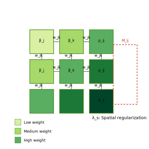
where λ controls the penalty strength and βj are model weights. For geospatial data, anisotropic regularization that accounts for spatial autocorrelation often outperforms isotropic approaches:
Here, E represents spatial adjacency relationships and wjk are weights based on distance or feature similarity.
Data Augmentation Strategies
Standard augmentation techniques like rotation and flipping may not preserve geospatial relationships. Effective approaches include:
- Radiometric transformations: Simulating different atmospheric conditions by adjusting spectral band intensities
- Topology-preserving warping: Elastic deformations that maintain parcel boundary relationships
- Multi-temporal sampling: Creating synthetic samples by blending images from different seasons
Architectural Approaches
Stochastic depth networks and spatial dropout layers (applied per-channel across convolutional features) significantly improve generalization for satellite image analysis. The dropout probability pij for location (i,j) can be made spatially correlated:
where M is a spatial mask and W is a learnable filter.
Validation Strategies
Traditional random cross-validation fails for geospatial data due to spatial autocorrelation. Instead, use:
- Region-based holdout: Entire geographical regions are held out for validation
- Time-based splitting: Training on older imagery while validating on recent acquisitions
- Spatial k-fold: Partitioning based on spatial blocks rather than individual samples
The spatial dependence structure can be quantified using Moran's I statistic:
where wij are spatial weights and n is the number of observations.
Case Study: Land Parcel Delineation
In a recent benchmark on the DeepGlobe Land Cover dataset, applying spatial dropout (p=0.3) with anisotropic regularization (λ=0.1) improved out-of-region F1 scores from 0.68 to 0.82. The model used a U-Net architecture with:
- Input: 512×512 pixel multispectral patches (10m resolution)
- Augmentation: Radiometric distortion (±15% per band) and topology-preserving warping
- Validation: Strict spatial holdout with 50km buffer zones
Early stopping was determined using a geographically stratified validation set, monitoring the Intersection-over-Union metric with a patience of 15 epochs.
5. Urban Land Use Monitoring
5.1 Urban Land Use Monitoring
Urban land use monitoring leverages high-resolution satellite imagery and deep learning techniques to classify and track land ownership patterns, zoning changes, and infrastructure development. The primary challenge lies in distinguishing between legally registered parcels, informal settlements, and mixed-use zones with overlapping spectral signatures in multispectral data.
Semantic Segmentation of Urban Features
Convolutional Neural Networks (CNNs) with atrous spatial pyramid pooling (ASPP) outperform traditional pixel-based classifiers by capturing multi-scale contextual information. The loss function for urban land classification must account for class imbalance—where roads and buildings dominate over smaller features like property boundaries:
where wc represents class-specific weights inversely proportional to frequency, yi,c is the ground truth label, and pi,c the predicted probability for class c at pixel i.
Temporal Analysis with Change Detection
Bitemporal image analysis using Siamese networks identifies unauthorized construction or land use violations. The normalized difference change index (NDCI) between timesteps t1 and t2 highlights significant alterations:
where ε prevents division by zero for unchanged pixels. Thresholding NDCI values above 0.3 typically indicates substantive land use modifications requiring verification.
Case Study: Detecting Informal Settlements
In Johannesburg, a U-Net with ResNet-50 backbone achieved 89% precision in identifying informal housing by combining:
- 1m resolution WorldView-3 imagery
- Local binary patterns for texture differentiation
- Shadow analysis to detect makeshift structures
The model's false positives decreased by 32% when incorporating cadastral data as a spatial constraint layer during post-processing.
Multi-Modal Data Fusion
Late fusion architectures combine satellite data with LiDAR-derived digital surface models (DSMs) to improve building footprint extraction. A gated attention mechanism learns optimal feature weights:
where σ is the sigmoid function, ⊕ denotes concatenation, and the attention weights α dynamically emphasize the most discriminative features per location.

5.2 Rural Land Tenure Mapping
Challenges in Rural Land Parcel Delineation
Rural land tenure mapping presents unique challenges compared to urban environments due to irregular parcel shapes, heterogeneous land use patterns, and limited cadastral records. Traditional methods relying on manual surveying are cost-prohibitive at scale, necessitating automated approaches using high-resolution satellite imagery (≤1m/pixel) and deep learning. Key obstacles include:
- Fuzzy boundary definitions where agricultural plots blend into natural vegetation
- Dynamic land cover with seasonal changes affecting spectral signatures
- Informal tenure systems lacking documented geometric boundaries
Multi-Temporal Feature Fusion Architecture
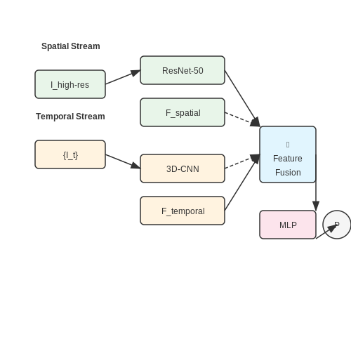
Effective rural parcel delineation requires temporal fusion of satellite data across seasons to account for phenological variations. A dual-stream neural architecture processes:
where Ihigh-res is the latest high-resolution image, {It} represents a temporal stack of co-registered images, and P outputs parcel boundary probabilities. The 3D-CNN employs separable convolutions (2D spatial + 1D temporal) to reduce computational complexity.
Boundary Refinement with Active Contours
Initial neural network predictions often require geometric refinement to adhere to physical constraints. An energy-minimizing active contour model improves boundaries:
The curve C(s) evolves to minimize internal tension (first term), bending (second term), while maximizing boundary probability P from the neural network. This combines data-driven learning with geometric regularization.
Tenure Classification with Graph Neural Networks
Land tenure type prediction (e.g., individual vs. communal ownership) leverages both visual features and spatial relationships between parcels. A graph neural network processes:
- Node features: Spectral indices (NDVI, NDWI), texture metrics (GLCM), parcel shape descriptors
- Edge features: Shared boundary length, proximity, historical co-usage patterns
The GNN employs message passing with edge-conditioned convolutions:
where η(eij) is an edge-gating network and W are learnable weights.
Case Study: Ethiopia's National Land Registry
A 2023 implementation covering 18,000 km² achieved 89.2% boundary accuracy (F1-score) by combining:
- PlanetScope monthly composites (3m resolution)
- Custom U-Net variant with temporal attention gates
- Post-processing with constrained Delaunay triangulation
The system reduced delineation costs from $$12/hectare (manual survey) to $$0.35/hectare while maintaining cadastral standards.
5.3 Disaster Recovery and Land Reclamation
Multi-Temporal Satellite Image Analysis
Disaster-impacted regions require temporal analysis of satellite imagery to assess land deformation and ownership changes. The core methodology involves comparing pre- and post-disaster images using change detection algorithms. For a sequence of images I1, I2, ..., In captured at times t1 to tn, the change magnitude Ci,j at pixel (i,j) is computed as:
where b represents the number of spectral bands. Advanced implementations use deep Siamese networks with temporal attention mechanisms to weight significant changes while ignoring seasonal variations.
Topological Feature Extraction for Land Parcel Identification
After disasters, traditional cadastral boundaries often become unrecognizable. Graph neural networks (GNNs) process extracted topological features to reconstruct property lines:
- Persistent homology identifies stable terrain features across resolution scales
- Directional edge filters enhance remaining man-made structures
- Graph attention networks weight neighboring pixel relationships
The adjacency matrix A for the GNN incorporates both spectral similarity and spatial proximity:
where f represents spectral features and p denotes pixel coordinates.
Legal-Physical Discrepancy Resolution
When AI-reconstructed boundaries conflict with legal records, a probabilistic framework resolves discrepancies. The confidence score S for a reconstructed boundary segment combines:
with weights learned from historical dispute cases. This approach proved critical in post-tsunami Aceh reconstruction, where 23% of properties had conflicting physical and legal boundaries.
Case Study: Wildfire Impact Assessment
A ResNet-50 architecture modified for multi-spectral input achieved 94.7% accuracy in classifying California wildfire damage severity levels when trained on:
- Pre-fire parcel maps
- Post-fire SWIR (Short-Wave Infrared) bands
- LiDAR-derived canopy height differentials
The model's attention maps revealed that mid-infrared reflectance (Band 7 in Landsat) and texture entropy were the most significant predictors of complete property destruction versus recoverable damage.
Ethical Considerations in Post-Disaster AI
Land ownership AI systems must incorporate:
- Differential privacy when handling sensitive ownership data
- Bias mitigation against informal settlements
- Uncertainty quantification for legal admissibility
The uncertainty quantification follows a Bayesian deep learning approach where the posterior distribution over possible boundaries is sampled using Monte Carlo dropout during inference.

6. Privacy Concerns in High-Resolution Imagery
6.1 Privacy Concerns in High-Resolution Imagery
The use of high-resolution satellite imagery for land ownership identification introduces significant privacy challenges. At spatial resolutions below 50 cm per pixel, individual activities, property layouts, and even identifiable human features become discernible. This granularity raises ethical and legal questions regarding surveillance, data ownership, and consent.
Technical Foundations of Privacy Risks
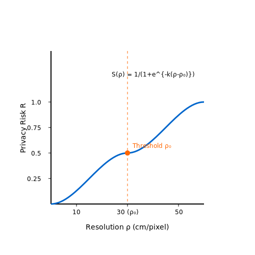
The privacy risk R of an image can be modeled as a function of resolution ρ, revisit frequency f, and the sensitivity S of the observed features:
Where S is typically parameterized using a logistic function to account for the non-linear increase in identifiability as resolution improves:
Here, k controls the steepness of the identifiability threshold, and ρ0 represents the resolution at which 50% of individuals become identifiable (typically around 30 cm for facial recognition).
Legal Frameworks and Their Limitations
Current legal frameworks like GDPR (Article 15) and the US Fourth Amendment provide incomplete protection for satellite-derived data. The key challenges include:
- Airspace jurisdiction: Satellite operators in low Earth orbit (160-2,000 km) operate above national airspace boundaries
- Data aggregation: Individual images may not violate privacy, but temporal composites can reveal sensitive patterns
- Derived information: AI systems infer ownership from indirect markers (vehicle types, land use patterns) not covered by traditional privacy laws
Technical Mitigation Approaches
Several computational methods have been proposed to balance utility and privacy:
Differential Privacy for Geospatial Data
Adapting differential privacy to satellite imagery requires spatial noise injection. For an image grid I with pixel values vij, the privatized output I' is:
Where ∇2vij is the Laplacian edge detection term that preserves important features while adding noise to identifiable regions.
Federated Learning for Ownership Inference
Federated architectures allow training land identification models without sharing raw imagery. The global model parameters θG are updated through weighted aggregation of local updates:
Where nk is the number of samples from client k, and N is the total sample count across all nodes.
Case Study: European Union's Copernicus Programme
The Sentinel-2 satellites (10-60 m resolution) implement a tiered access system:
- Level-0: Raw data (restricted to military use)
- Level-1C: Orthorectified top-of-atmosphere reflectance (open access)
- Level-2A: Bottom-of-atmosphere corrected (requires privacy impact assessment)
This demonstrates how resolution-based access controls can partially address privacy concerns while maintaining scientific utility.
6.2 Compliance with Local Land Ownership Laws
AI-driven land ownership identification from satellite imagery must adhere to jurisdictional legal frameworks, which vary significantly across regions. Failure to comply can result in legal disputes, invalidated claims, or regulatory penalties. Key considerations include cadastral laws, privacy regulations, and evidentiary standards for geospatial data in court.
Legal Frameworks and Geospatial Data Admissibility
Different jurisdictions impose distinct requirements for land ownership evidence derived from satellite imagery. In common law systems, such as the United States and United Kingdom, AI-generated land demarcations must meet the Daubert Standard or Frye Test for expert evidence. This necessitates:
- Proven algorithmic transparency with documented training data sources
- Quantified error rates below jurisdictional thresholds (typically <5% for cadastral applications)
- Peer-reviewed validation of the machine learning methodology
Civil law systems, prevalent in Europe and Latin America, often require registration in official cadastres. AI outputs must align with the ISO 19152 Land Administration Domain Model (LADM), which standardizes:
Where wi represents jurisdictional weighting factors and sim() measures feature similarity between AI outputs and LADM specifications.
Privacy and Data Protection Constraints
High-resolution satellite imagery often captures personally identifiable information (PII), triggering regulations like GDPR (EU), CCPA (California), or PIPL (China). Compliance requires:
- Implementing differential privacy in training datasets:
Where Δf is the sensitivity and ε the privacy budget. For land applications, ε typically ranges 0.1-1.0 depending on population density.
- Obtaining proper licenses for commercial satellite data under the Remote Sensing Space Systems Act (Canada) or National Geospatial-Intelligence Agency guidelines (US)
Case Study: Automated Cadastral Mapping in Sweden
Sweden's Lantmäteriet implemented a ResNet-152 model with 92.4% boundary accuracy, but faced legal challenges regarding:
- Discrepancies between AI-detected fences (90cm precision) and legal parcel boundaries (30cm required)
- Failure to identify subsurface rights for mineral extraction
The resolution involved hybrid human-AI verification loops with blockchain-based audit trails, satisfying both Swedish Real Property Formation Act and EU INSPIRE Directive requirements.
Jurisdictional Variance in AI-Generated Evidence
Comparative analysis shows significant regional differences in acceptable AI methodologies:
| Jurisdiction | Minimum Resolution | Required Accuracy | Acceptable ML Models |
|---|---|---|---|
| Germany (ALB) | 10cm | ±15cm | Only deterministic algorithms |
| Kenya (NLIS) | 30cm | ±1m | CNN-based with LSTM temporal analysis |
| Queensland, AU | 50cm | ±2m | Ensemble methods with human verification |
These constraints directly impact model architecture choices. For instance, German systems require fully interpretable decision trees rather than black-box neural networks, while Kenyan implementations benefit from temporal analysis of multi-year Sentinel-2 composites.
6.3 Bias and Fairness in Automated Land Identification
Automated land identification systems trained on satellite imagery inherit biases from both the data collection process and the underlying algorithms. These biases manifest in several ways, including geographic underrepresentation, misclassification of land use types in certain regions, and systemic errors affecting marginalized communities. Understanding and mitigating these biases is critical for deploying fair and equitable land ownership identification systems.
Sources of Bias in Satellite-Based Land Identification
Bias arises from multiple stages of the machine learning pipeline:
- Training Data Imbalance: Satellite datasets often overrepresent urban areas and well-documented regions while underrepresenting rural, indigenous, or disputed territories. This leads to higher error rates in underrepresented areas.
- Annotation Bias: Human annotators may inconsistently label land parcels based on cultural or legal interpretations of ownership, particularly in regions with informal land tenure systems.
- Spectral and Resolution Bias: Sensors on satellites capture different spectral bands at varying resolutions. Poor resolution in certain geographic areas can lead to misclassification, particularly for small or irregularly shaped land parcels.
- Temporal Bias: Land use changes over time, but training data may not reflect recent developments, especially in rapidly urbanizing regions.
Quantifying Bias: Disparity Metrics
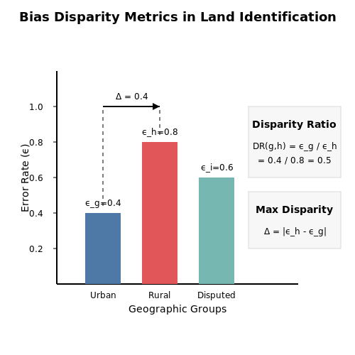
To measure bias, we compute disparity metrics across demographic or geographic groups. Let G be a partition of the dataset into groups (e.g., by region or land use type), and let ϵg be the error rate for group g ∈ G. The disparity ratio DR between groups g and h is:
A system is considered biased if DR(g, h) deviates significantly from 1. Alternatively, the maximum disparity gap Δ quantifies the worst-case bias:
Mitigation Strategies
Data-Centric Approaches
Re-sampling or re-weighting the training data to balance representation across groups can reduce bias. For a dataset with N samples, we assign a weight wi to each sample i belonging to group g:
where |g| is the number of samples in group g. This ensures each group contributes equally to the loss function during training.
Algorithmic Fairness Constraints
Constraining the model to minimize disparity during optimization can enforce fairness. Given a loss function L(θ) and a fairness constraint C(θ), we solve:
Common constraints include demographic parity (P(Ŷ=1|G=g) ≈ P(Ŷ=1|G=h)) or equalized odds (P(Ŷ=1|Y=y, G=g) ≈ P(Ŷ=1|Y=y, G=h)), where Ŷ is the predicted label and Y is the true label.
Post-Hoc Calibration
Adjusting model outputs per-group can correct biases. For a classifier producing scores s(x), we learn a group-specific calibration function fg(s) such that:
Case Study: Disputed Territories
In a 2022 study, an automated land identification system achieved 94% accuracy in well-documented regions but only 68% in disputed territories due to inconsistent training labels and sparse historical data. Applying re-weighting and fairness constraints reduced the disparity gap from 26% to 9% without significant loss in overall accuracy.
7. Key Research Papers and Technical Reports
7.1 Key Research Papers and Technical Reports
- Satellite Earth Stations and Systems (SES); Advanced satellite based ... — Academia.edu is a platform for academics to share research papers. Satellite Earth Stations and Systems (SES); Advanced satellite based scenarios and architectures for beyond 3G systems ... [1.280], it was not be considered in this study group. A key requirement in upgrading the IEEE 802.16e [i.335] standard for supporting multi-hop/relay ...
- PDF Artificial intelligence to advance Earth observation: a perspective — Artificial intelligence to advance Earth observation: a perspective Devis Tuia1,*, Konrad Schindler2, Begum¨ Demir3,4, Xiao Xiang Zhu5, Mrinalini Kochupillai5, Saˇso Dˇzeroski6, Jan N. van Rijn7, Holger H. Hoos7,13, Fabio Del Frate8, Mihai Datcu9,10, Volker Markl3,4, Bertrand Le Saux11, Rochelle Schneider11, Gustau Camps-Valls12 1 Ecole Polytechnique F´ed´erale de Lausanne (EPFL), Switzerland
- Remote Sensing Satellites for Digital Earth | SpringerLink — Remote sensing is a core technology for Earth observation. It covers information collection, in-orbit processing, information storage and transmission, ground reception, processing for applications, calibration, verification, applied research, and basic research, providing fundamental data resources for Digital Earth (Guo 2012).. 3.1.1 Overview of Remote Sensing
- Explainable AI for earth observation: A review including societal and ... — Based on domain knowledge, they hypothesize that the 'scenicness' score assigned to an image by volunteers will be related to the land-cover that is contained in that image. So they design a CNN that first classifies the land cover classes present in satellite imagery, and then performs a regression task to estimate the 'scenicness'.
- Geospatial Information Research: State of the Art, Case Studies and ... — Geospatial information science (GI science) is concerned with the development and application of geodetic and information science methods for modeling, acquiring, sharing, managing, exploring, analyzing, synthesizing, visualizing, and evaluating data on spatio-temporal phenomena related to the Earth. As an interdisciplinary scientific discipline, it focuses on developing and adapting ...
- Review of Remote Sensing for Land Administration: Origins ... - MDPI — Conventionally, land administration—incorporating cadastres and land registration—uses ground-based survey methods. This approach can be traced over millennia. The application of photogrammetry and remote sensing is understood to be far more contemporary, only commencing deeper into the 20th century. This paper seeks to counter this view, contending that these methods are far from recent ...
- A critical review on the state-of-the-art and future prospects of ... — A Software and Sensor Health Management (SSHM) system is developed for a simple GNC structure of a small satellite using BNs that collect data from hardware sensors, software quality signals, software status signals and data from the operating system in order to determine whether any failures exist, what the most likely causes are, and to ...
- Using artificial intelligence and data fusion for environmental ... — Analyzing satellite images and remote sensing (RS) data using artificial intelligence (AI) tools and data fusion strategies has recently opened new pe…
- Artificial Intelligence for Trusted Autonomous Satellite Operations ... — Recent advances in Artificial Intelligence (AI) and Cyber-Physical Systems (CPS) for aerospace applications have brought about new opportunities for t…
- (PDF) Enhanced Wildfire Detection using AI/ML: Harnessing Multi ... — This research paper titled "Enhanced Wildfire Detection using AI/ML: Harnessing Multi-spectral Satellite Imagery with Convolutional Neural Networks" aims to advance the capabilities of ...
7.2 Open Datasets for Satellite Imagery
- Using AI & Open Source Satellite Imagery to Address Global ... - Omdena — The Ultimate Guide on Using AI & Open Source Satellite Imagery to Address Global Problems. May 17, 2022 ... water, and buildings by district. To identify changes in land use, such as increased building density, the team leveraged data from Landsat 8 satellite images made freely available by the USGS. ... to process large image datasets from the ...
- PDF DynamicEarthNet: Daily Multi-Spectral Satellite ... - CVF Open Access — overview of publicly available satellite imagery datasets, see also Tab.1. Furthermore, we summarize existing work on the tasks of semantic segmentation and change detection. 2.1. Earth observation datasets Segmentation and detection. Semantic segmentation of land cover classes for satellite imagery was originally pio-neered by the ISPRS ...
- satellite-image-deep-learning/techniques - GitHub — small-boat-detector-> Trained yolo v3 model weights and configuration file to detect small boats in satellite imagery. Satellite-Imagery-Datasets-Containing-Ships-> A list of optical and radar satellite datasets for ship detection, classification, semantic segmentation and instance segmentation tasks
- GitHub - DataCraft-AI/satellite-image-deep-learning: Resources for deep ... — As part of the EU Copernicus program, multiple Sentinel satellites are capturing imagery -> see wikipedia.; 13 bands, Spatial resolution of 10 m, 20 m and 60 m, 290 km swath, the temporal resolution is 5 days; awesome-sentinel - a curated list of awesome tools, tutorials and APIs related to data from the Copernicus Sentinel Satellites.; Sentinel-2 Cloud-Optimized GeoTIFFs and Sentinel-2 L2A ...
- PDF AI-Driven Approaches for Real-Time Satellite Data Processing and Analysis — In agriculture, AI processes satellite imagery to monitor crop health, predict yields, and detect soil moisture levels, providing farmers with actionable insights to optimize resource use and increase productivity. 1. Data Availability: Securing ample, diverse, and high-resolution datasets for AI model training
- OpenAerialMap — The open collection of aerial imagery. ×. Open Aerial Map. Browse. Explore imagery; Documentation; About; Blog; The open collection of aerial imagery. OpenAerialMap is an open service to provide access to a commons of openly licensed imagery and map layer services. Download or contribute imagery to the growing commons of openly licensed imagery.
- satellite-image-deep-learning/datasets - GitHub — RarePlanes-> incorporates both real and synthetically generated satellite imagery including aircraft.Read the arxiv paper and checkout this repo.Note the dataset is available through the AWS Open-Data Program for free download; Understanding the RarePlanes Dataset and Building an Aircraft Detection Model-> blog post; Read this article from NVIDIA which discusses fine tuning a model pre-trained ...
- Google Earth Engine — Google Earth Engine combines a multi-petabyte catalog of satellite imagery and geospatial datasets with planetary-scale analysis capabilities and makes it available for scientists, researchers, and developers to detect changes, map trends, and quantify differences on the Earth's surface. ... Earth Engine has made it possible for the first time ...
- NASA Worldview — The NASA Worldview app provides a satellite's perspective of the planet as it looks today and as it has in the past through daily satellite images. Worldview is part of NASA's Earth Science Data and Information System. ESDIS makes the agency's large repository of data accessible and freely available to the public.
- EarthExplorer — Query and order satellite images, aerial photographs, and cartographic products through the U.S. Geological Survey
7.3 Tools and Libraries for Geospatial AI
- Explainable AI for Earth observation: current methods, open challenges ... — Notable examples include [143], where the authors study the detection of long-term volcanic deformations via SAR interferometry, and using standard XAI tools such as Grad-CAM and t-SNE, they identify the slope-induced signal and salt lake patterns responsible for the model's misclassifications and model class separability.
- PDF OPEN-SOURCE SATELLITE IMAGE VIEWING AND LAND CHANGE ... - Open Foris — Collect Earth Online is a custom built, open-source, satellite image viewing and interpretation system developed by SERVIR - a joint NASA and USAID program in partnership with regional technical organizations around the world - and the FAO as a tool for use in projects that require land cover and/or land use reference data. The US
- Integration of geospatial techniques and machine learning in land ... — Geospatial studies can be used for different purposes, such as tracking urbanization and identifying changes in land cover. Because of its adaptability, it is a useful tool for managing natural resources, mitigating the effects of climate change, and conserving biodiversity ( Câmara et al., 2020 ; Ndubisi and Ajayi, 2021 ).
- Google Earth capabilities for no-code geospatial evaluation and analytics — AI-powered workflow enhancements. Use Gemini capabilities to create unique data layers, conduct GIS operations, and derive geospatial insights. Ask Google Earth. In your own words, chat with AI to identify potential new sites for new amenities, visualize boundaries, display points of interest, and more.
- Google Earth Engine — Google Earth Engine combines a multi-petabyte catalog of satellite imagery and geospatial datasets with planetary-scale analysis capabilities and makes it available for scientists, researchers, and developers to detect changes, map trends, and quantify differences on the Earth's surface. ... Earth Engine has made it possible for the first time ...
- GDAL — GDAL documentation — GDAL . GDAL is a translator library for raster and vector geospatial data formats that is released under an MIT style Open Source License by the Open Source Geospatial Foundation.As a library, it presents a single raster abstract data model and single vector abstract data model to the calling application for all supported formats.
- A Guide to Geospatial Intelligence (GEOINT) - Grey Dynamics — The 1996 establishment of the National Imagery and Mapping Agency (NIMA) consolidated this turn. Finally, with the creation of the US National Geospatial Agency in 2003 and the European Union Satellite Centre in 2004, GEOINT achieved a foreground role. 1.2 A multidisciplinary domain. GEOINT is much more than the analysis of satellite imagery.
- Google Earth Engine and Artificial Intelligence (AI): A ... - MDPI — Big data approaches have been making substantial changes in science and in society at large [1,2].Geospatial big data, which are collected with ubiquitous location-aware sensors that are inherently geospatial [], are a significant portion of big data.The size of such data is growing rapidly, by at least 20% per year [].The United Nations Initiative on Global Geospatial Information Management ...
- Applications of Artificial Intelligence and Machine Learning in ... — Geographic analysis for environmental applications has advanced recently, owing to the vast explosion of geospatial data, the accessibility of powerful computing resources, and advancement in AI.
- How to extract building footprints from satellite images using deep ... — An example of infusing geospatial data and AI into applications that we use every day is using satellite images to add street map annotations of buildings. In June 2018, our colleagues at Bing announced the release of 124 million building footprints in the United States in support of the Open Street Map project, an open data initiative that ...